Cape Peninsula
[1] The Peninsula has been an island on and off for the past 5 million years, as sea levels fell and rose with the ice age and interglacial global warming cycles of, particularly, the Pleistocene.
The peninsula is mostly the mountainous remnant of very old durable sandstone formations with low dip, deposited unconformably on an ancient underlying granite peneplain.
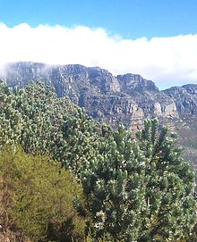
The climate is of the Mediterranean type, with predominantly winter rainfall and mild temperatures, and the natural vegetation is exceptionally diverse, with an unusually large number of endemic plant species for an area of this size, many of which are endangered, and threatened by human activity and encroachment, but are to some extent protected on the large part of the peninsula which is in Table Mountain National Park.
The rocky uplands have historically avoided development because of difficult access, poor soils and steep slopes, and more recently have been legally protected as being of high ecological importance, but are threatened by illegal land invasion and informal settlement.
[3] The sedimentary rocks of the Cape Supergroup, of which parts of the Graafwater and Peninsula Formations remain, were uplifted between 280 and 21S million years ago, and were largely eroded away during the Mesozoic.
The landscape is dominated by sandstone plateaux and ridges, which generally drop steeply at their margins to the surrounding debris slopes, interrupted by a major gap at the Fish Hoek–Noordhoek valley.
[9] The basal rocks were eroded to a relatively featureless peneplain with exposed granites covering most of the peninsula south of Lion's Head and Devil's Peak.
The Graafwater Formation can be clearly seen in the cutting on the second hairpin bend as the Ou Kaapse Weg (road) goes up the slope from Westlake on to the Silvermine plateau.
The deeper soils of the colluvial slopes which are underlain by shale or granite tend to be heavier, orange to red, less acid and richer in nutrients.
However, according to the International Hydrographic Organization agreement that defines the ocean boundaries, the meeting point is at Cape Agulhas, about 200 kilometres (120 mi) to the southeast and the most southerly tip of the African continent.
The winter rain is a consequence of frontal depressions developed from the circumpolar westerlies, which occur at least once per week in normal mid-winter from June to August.
[3] Variations in temperature are not great due to the moderating effect of the adjacent sea, the narrow land mass, and fairly low maximum altitudes of the mountains.
The coastal waters surrounding the Cape Peninsula were proclaimed as a marine protected area in 2004, include several no-take zones, and are part of the national park.
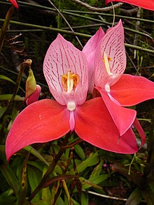
These protected areas are a World Heritage Site, and an estimated 2,200 species of plants are confined to Table Mountain range - which are at least as many as occur in the whole of the United Kingdom.
Although they are quite widespread on the Back Table, the best (most certain, and close-up) place to view these beautiful blooms is in the "Aqueduct" off the Smuts Track, halfway between Skeleton Gorge and Maclear's Beacon.
[26] In the early 1900s commercial pine plantations were planted on these slopes all the way from the Constantiaberg to the front of Devil's Peak, and even on top of the mountains, but these have now been largely cleared allowing fynbos to flourish in the regions where the indigenous Afromontane forests have not survived, or never existed.
[27] This was originally probably to maintain a productive stock of edible bulbs (especially watsonians)[27] and to facilitate hunting, and later, after the arrival of pastoralists,[29] to provide fresh grazing after the rains.
[27][28] Thus the plants that make up fynbos today are those that have been subjected to a variety of fire regimes over a very long period, and their preservation now requires regular burning.
Despite intensive conservation efforts the Table Mountain range has the highest concentration of threatened species of any continental area of equivalent size in the world.
Other invasive plants include black wattle, blackwood, Port Jackson and rooikrans (All Australian members of the acacia family), as well as several Hakea species and bramble.
[3] Fynbos: Other: The most common mammal on the mountain was the dassie (the South African name, from Afrikaans, pronounced "dussy"), or rock hyrax.
However these new haunts are also within easy reach of Cape Town's suburbs, which brings them into conflict with humans and dogs, and the risk of traffic accidents.
In addition, their sleeping sites are noted each evening, so that monitors armed with paint ball guns can stay with the troop all day, to ward them off from wandering into the suburbs.
As an exotic species, they were almost eradicated through a culling programme initiated by the South African National Parks to make way for the reintroduction of indigenous klipspringers.
On the lower slopes of Devil's Peak, above Groote Schuur Hospital, an animal camp bequeathed to the City of Cape Town by Cecil John Rhodes has been used in recent years as part of the Quagga Project.
These long term practices are thought to have influenced the development of fynbos in areas where thickets would likely be the dominant vegetation community, and encouraged greater floral biodiversity.
About 2000 years ago the San were displaced by Khoikhoi who were mainly nomadic pastoralists who kept fairly large numbers of sheep and cattle at lowland sites in the central and northern peninsula during the dry season.
[3] Colonisation by the Dutch had an immediate transformative effect on the lower altitude ecosystems of the northern peninsula when agriculture was introduced, and rapidly expanded between Table Bay and Wynberg.
[3] Extensive plantations of fast growing alien trees were established during the mid to late 19th century on the slopes of the central Peninsula and Table Mountain (mostly pines and eucalypts), and on the sands of the Cape Flats (mostly Australian acacias).
[3] Cape Town grew rapidly during the 20th century: By the 1960s the population reached half a million, In the late 1980s discriminatory legislation was relaxed and a large influx of rural people moved in and started informal settlements on open ground.