Taconic State Parkway
Franklin D. Roosevelt, who had long envisioned a scenic road through the eastern Hudson Valley, was instrumental in making it a reality as a way to provide access to existing and planned state parks in the region.
The road narrows shortly after the county line in the town of Putnam Valley, with the roadways reverting to two lanes and the shoulders replaced by soft curbs, in preparation for the rugged terrain of the next 12 miles (19 km).
[6] A short distance beyond that, a stone bridge marks the NY 301 exit that serves as the main access to the state park and the bathing area and hiking trails at nearby Canopus Lake.
This area, rural and agricultural when the highway was built, has become more developed in the last decades, with residential subdivisions and golf courses replacing the silos and haystacks as landmarks off the road.
Its slow undulation with the landscape continues past the now closed Skidmore Road grade crossing as it heads due north into the town of Pleasant Valley and the less developed half of Dutchess County.
Several other local roads cross the parkway until it reaches one of its straightest stretches, which then curves to the first grade-separated exit in several miles, US 44, the other main route to Poughkeepsie, between Millbrook and Pleasant Valley.
From here the parkway bends eastward again, entering the town of Milan and climbs slowly through generally wooded area, passing another grade crossing at Cold Spring Road.
After another long bend east, the Taconic goes north again and crosses into Columbia County just past Roeliff Jansen Kill Multiple Use Area and the Jackson Corners Road (CR 2) exit.
[12] Grade intersections, usually a feature engineers tried to avoid, which initially helped keep local east–west routes open[14] and connect the parkway to the landscape it traversed,[15] have since either been closed or replaced by overpasses.
Sociologist Lewis Mumford, who often criticized the effect of superhighway construction on contemporary cities, always advised friends traveling up from New York to visit him at his house in Amenia that they should take the Taconic.
In its early days, the Taconic State Parks Commission (TSPC) lacked the money to hire a full engineering staff, in spite of terrain that presented some major challenges.
The roadway was crowned, with storm drain grates at the edge since there was no shoulder, to keep water from forming deep puddles that could cause accidents (these have been eliminated from modernized sections of the parkway in Westchester).
As the road was extended north during the 1930s, it became clear that the wider medians improved safety without sacrificing beauty, and starting with the NY 52 exit in East Fishkill they were made a standard element of the parkway's design.
[21] It would take nearly four decades to complete from the initial parkway proposal by TSPC chair Franklin D. Roosevelt in 1925 to the opening of the last segment in 1963, due in part to a lengthy hiatus resulting from World War II.
Since its completion it has been renovated, particularly in Dutchess and Westchester counties, reflecting the change in its role from park access route and scenic drive to important regional transportation artery.
He became more interested in the possibilities of automobile touring ten years later when, paralysis resulting from polio having cost the effective use of his legs, Roosevelt began frequently taking his friends on such trips around the region.
He would have the parkway avoid the rugged terrain of central Putnam County and instead follow the Hudson from the Bear Mountain Bridge up to Cold Spring, where it would then go northeast to the Tri-State Park.
[39] Roosevelt eventually won, pointing to a new state highway planned to run north from the bridge (today's US 9W) and that a more direct route would better serve recreational traffic from the city.
Moses, who also served as New York's Secretary of State for two years during this period, used his influence with the legislature and control of the parks budgeting process to keep the TSPC's finances low enough that it could barely maintain existing facilities under its jurisdiction, much less acquire right-of-way or hire staff.
[48][50] Later that year the lack of funds, along with resistance from local property owners, led the commission to abandon Roosevelt's original hope of routing the parkway over Stissing Mountain.
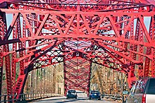
[53] Eight months later the two rivals were at the north portal of the triple-hinged steel suspension bridge built over the reservoir, at 750 feet (230 m) the longest of that type in the world at the time,[11] for the ribbon cutting ceremony.
[67] Dewey also advocated the construction of a statewide "thruway" system of limited-access divided highways that would, unlike the parkways, be designed for buses and trucks as well as automobiles and serve commercial needs.
The proposed Berkshire Thruway terminus gave the TSPC renewed vigor in continuing construction, but meant that it had to abandon plans for a connection to the Tri-State Park, its original mandate.
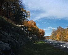
[68] As the designers and builders pushed north into Columbia County, connecting Lake Taghkanic State Park at last to the parkway, they took advantage of the more open and rolling terrain to improve the road's scenic possibilities.
It did not appear likely that this would happen in any event, between the likely end of the Taconic at the Berkshire section of the Thruway and the recently announced plan to build the Adirondack Northway from Albany to Canada as part of the new Interstate Highway System.
[77] In 1964, I-84 was built through Dutchess and Putnam counties, giving the middle of the Taconic a controlled-access intersecting route that made it possible to access the Danbury and Newburgh areas via the parkway.
[91][92] The state had previously added turn lanes and widened the median so that a school bus would not block the road, but members of the county's Traffic Safety Board, including the sheriff, said that accidents were still too frequent.
[citation needed] When the parkway was listed on the National Register in late 2005,[94] the entire right-of-way from Kensico Circle to the Thruway merge was included, creating a 7,067-acre (2,860 ha)[95] linear historic district.
[b] The entire parkway, right-of-way and supporting buildings and structures were considered contributing except for the 15 miles (24 km) of rebuilt roadway between the former Hawthorne Circle and Crom Pond Road and 23 bridges in the southern three counties.
[98] In July 2009, Diane Schuler of West Babylon crashed her van head-on into an oncoming sport utility vehicle (SUV) while driving south in the northbound lanes[99] approximately 1.7 miles (2.7 km) north of the Pleasantville Road exit.