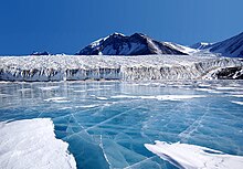
Taylor Valley
The distinctive dolerite intrusion—or sill—is a remnant of a massive volcanic plumbing system that produced major eruptions about 180 million years ago.
A gentle ridge, the northern arm of Nussbaum Riegel, which trends eastward to the south of Suess Glacier and Lake Chad in Taylor Valley.
The name was suggested by Diane McKnight, leader of United States Geological Survey (USGS) field teams which studied the hydrology and geochemistry of streams and ponds in the Lake Fryxell basin, Taylor Valley, 1987–94.
Lake 3 nautical miles (5.6 km; 3.5 mi) long, between Canada and Commonwealth Glaciers at the lower end of Taylor Valley.
Péwé during United States Navy Operation Deep Freeze, 1957–58, and was named by him for Doctor Fritiof M. Fryxell, glacial geologist of Augustana College, Illinois.
A ridge trending north–south, transverse to the axis of Taylor Valley, forming a divide 100 metres (330 ft) above sea level between Lake Fryxell and Explorers Cove, McMurdo Sound.
A glacial meltwater stream, 0.65 nautical miles (1.20 km; 0.75 mi) long, flowing northeast from the extremity of Canada Glacier into the southwest end of Lake Fryxell, close east of Bowles Creek, in Taylor Valley.
The name was suggested by hydrologist Diane McKnight, leader of USGS teams that made intensive studies of the hydrology of streams of the Lake Fryxell basin, 1987–94.
A glacial meltwater stream which flows south along the east margin of Canada Glacier into the west end of Lake Fryxell.
The name was suggested by hydrologist Diane McKnight, leader of a USGS team which made extensive studies of the hydrology and geochemistry of streams and ponds in the Lake Fryxell basin, 1987–94.
Named after USGS hydrologist Edmund Andrews, a member of the field team who studied glacier hydrology during the 1987–88 and 1991–92 summer seasons.
A glacial meltwater stream, 1.2 nautical miles (2.2 km; 1.4 mi) long, flowing south from an ice field west of Mount Falconer to the north-central shore of Lake Fryxell.
The name was suggested by hydrologist Diane McKnight, leader of a USGS team that made extensive hydrological studies in the Lake Fryxell basin, 1987–94.
The name acknowledges support received by the USGS field team in Taylor Valley from United States Navy Squadron VXE-6 and its twin engine UH-1N "Huey" helicopters.
Glacier which flows in a southeast direction and enters the north side of Taylor Valley immediately west of Mount Coleman.
Named for the Commonwealth of Australia, which made a financial grant to the BrAE and contributed two members to the Western Geological Party which explored this area.
A glacial meltwater stream, 1.4 nautical miles (2.6 km; 1.6 mi) long, draining from the west margin of Commonwealth Glacier into the northeast end of Lake Fryxell.
The name was suggested by Diane McKnight, leader of a USGS team that studied the hydrology of streams flowing into Lake Fryxell in several seasons, 1987–94.
Studied on the ground during United States Navy Operation Depp Freeze, 1957–58, by Troy L. Péwé who suggested the name in association with Commonwealth Glacier.
The name was suggested by Diane McKnight, leader of a USGS team which made extensive studies of the hydrology and geochemistry of streams and ponds in the Lake Fryxell basin, 1987–94.
A glacial meltwater stream, 2.6 nautical miles (4.8 km; 3.0 mi) long, flowing north from Crescent Glacier to the south-central shore of Lake Fryxell.
The name was suggested by hydrologist Diane McKnight, leader of a USGS team that made extensive studies of the hydrology and geochemistry of streams and ponds in the Lake Fryxell basin, 1987–94.
The name was suggested by Diane McKnight, leader of USGS teams which made extensive studies of the hydrology of streams in the Lake Fryxell basin, 1987–94.
A glacial meltwater stream, 0.5 nautical miles (0.93 km; 0.58 mi) long, which flows from the snout of Canada Glacier.
The name was suggested by Diane McKnight, USGS hydrologist working in the Lake Fryxell basin, 1987–94, and alludes to the many aeolian deposits of fine sands along the creek, indicative of strong winds blowing around the south end of Canada Glacier during the winter.
Named from "They Called the Wind Maria," a song in Paint Your Wagon, the American musical play by Lerner and Loewe.
A glacial meltwater distributary stream, 0.25 nautical miles (0.46 km; 0.29 mi) long, which flows east from Maria Creek (q.v.)
The name was suggested by hydrologist Diane McKnight, leader of a USGS team which made extensive studies of the hydrology and geochemistry of streams and ponds in the Lake Fryxell basin, 1987–94.
Named after USGS hydrologist Elizabeth C. Bowles, a member of the field team in the 1987–88 summer season, who conducted a study of organic geochemistry of streams flowing into Lake Fryxell.
The name was suggested by hydrologist Diane McKnight, leader of the USGS team which made extensive studies of the hydrology and geochemistry of streams and ponds in the Lake Fryxell basin, 1987–94.