Te Tātua a Riukiuta
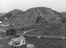
Te Tātua a Riukiuta was probably the most complex volcano in the Auckland volcanic field, consisting of five significant scoria cones and about a dozen smaller scoria mounds, sitting inside a large explosion crater.
Most of these lava tunnels have collapsed but sections of them form caves and can be accessed from private properties in the area.
[2] Te Tātua a Riukiuta was once the site of a pā, occupied during the Waiohua confederation era of the 17th and 18th centuries.
[6] Te Tātua a Riukiuta has retained Māori earthworks from that era such as kumara pits and terracing.
[citation needed] The area has been drastically quarried over the years for the red scoria it contains, and only one of the three large peaks (Te Tātua a Riukiuta / Big King) remains today, largely because of the water reservoir that was built on its summit at the beginning of the 20th century.
The legislation specified that the land be held in trust "for the common benefit of Ngā Mana Whenua o Tāmaki Makaurau and the other people of Auckland".