Teesta River
The river flows further down through Mekhliganj and Haldibari in Cooch Behar district, where it is spanned by Joyee Setu, the longest roadway bridge of West Bengal with length 3.8 kilometres.
Here the Teesta completes its journey in India and enters Bangladesh in Dahagram, Rangpur Division.
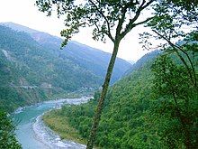
At lower elevations, tropical deciduous trees and shrubs cover the surrounding hills; alpine vegetation is seen at the upper altitudes.
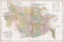
[6][7] In the past, the Teesta flowed south from Jalpaiguri in three channels: the Punarbhaba, Atrai and Karatoya Rivers.
[8] India has an estimated total hydroelectric power potential of 84 GW at 60% load factor.
[10] Disputes over the appropriate allocation and development of the water resources of the river have remained a subject of conflict between India and Bangladesh for almost 35 years, with several bilateral agreements and rounds of talks failing to produce results.
[30] In recent developments, Bangladesh's interim government water advisor, Syeda Rizwana Hasan, told news agency PTI (Press Trust of India) on September 1, 2024, that both upper and lower riparian countries must follow international water-sharing principles.
If a treaty remains out of reach, it could mark a significant shift in India-Bangladesh relations if diplomacy fails.
[10] The Teesta river has preserved good imprints of climatic and tectonics along its valleys and catchments.
The interrelationship between climate, erosion, deposition and tectonic activities is not properly understood to date.