Tejon Pass
Interstate 5, which connects Southern California with the San Joaquin Valley and the north, reaches its highest point in the state, 4,144 feet (1,263 m),[2] near the summit of Tejon Pass.
[4] On its northward slope lies Fort Tejon State Historic Park, the site of a former U.S. Army post, first garrisoned on August 10, 1854.
[10] In the late 18th century, El Camino Viejo, a road between Los Angeles and the Mission Santa Clara de Asis began to be used for travel north and south along the western San Joaquin Valley.
This route to the pass diverted from the El Camino Viejo at Elisabeth Lake, and from 1849 to before 1854 it was the main road connecting the southern part of the state to the trail along the eastern side of the San Joaquin Valley to the goldfields to the north.
The Butterfield Overland was discontinued in 1861 but was replaced by the Telegraph Stage Line, which stopped at almost all the former stations, including Gorman's, where the horses were changed.
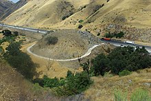
[16] A section of the highway known as "Dead Man's Curve," was the "scene of many accidents on the narrow old road,"[17] and in July 1932 it took the life of Jack Klieby, 33, who deliberately drove his truck, transporting gasoline, off the roadway to avoid hitting oncoming automobiles.
That work "supersedes the worst portions of the old twenty-foot Grapevine Canyon Highway, shortens the length of the road by approximately eight-tenths of a mile and eliminates 2,937 degrees of curvature or the equivalent of eight complete circles," according to R.M.
The 40-mile stretch of Interstate 5 between Grapevine and Castaic is sometimes closed by the California Highway Patrol,[20] generally because of the icy conditions combined with the steep grade of the pass, and the high traffic during the winter holidays.
[21] The Highway Patrol is also concerned, especially with the number of big-rigs that pass through, that one accident in the snowy conditions might force traffic to slow down or come to a complete stop, leaving hundreds of vehicles stalled at once.