Television Infrared Observation Satellite
Weather Bureau, the National Advisory Committee for Aeronautics, and the RCA was convened to discuss a satellite meteorological program and design objectives.
The committee recommended that such a program should provide observations of cloud cover with television cameras at coarser and finer resolutions, accompanied by infrared measurements of Earth's radiation; the goal of the first meteorological satellites would be to trial experimental television techniques, validate sun- and horizon-based sensors for spacecraft orientation, and collect meteorological data.
[6] Development of the TIROS satellite payload was contracted to the Army Signal Corps Laboratories and $3.6 million was allocated to Air Force Systems Command for use of the Thor launch vehicle.
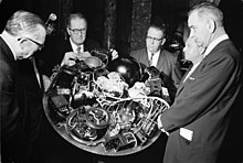
The acquisition of the TIROS project from ARPA by NASA was seen as a means to provide good publicity and validate the existence of the nascent civilian agency.
[12][6] However, only the optical system was included in the first TIROS payload, TIROS-1, launched on April 1, 1960, as the first U.S. satellite to carry a television camera.
[16] However, delays and the high cost of the Nimbus program ultimately led to TIROS-based spacecraft serving as the United States' fleet of operational weather satellites.
[27] The primary goal of the first TIROS satellites was to trial the use of spaceborne television camera systems for imaging cloud cover.
[19] Following TIROS-1, the engineering and mission design of successive TIROS spacecraft were intended to resolve shortcomings observed in earlier iterations.
[28][30] The cameras on the first eight TIROS satellites were also located on the base plate and aligned parallel to the spacecraft's axis of rotation.
[33] The first generation of TIROS satellites carried two 0.5 in (13 mm) diameter Vidicon line-scan cameras, typically with different fields of view supporting different angular resolution.
[28][33] The magnetic tape recorder on early iterations of TIROS could store a total of 64 pictures taken at fixed 30-second intervals, equivalent to at most two orbits of data.
[34] The camera shutters made possible the series of still pictures that were stored and transmitted back to earth via 2-watt FM transmitters as the satellite approached one of its ground command points.
[citation needed] TIROS-8 served as a test run of the new APT system, allowing images to be readily broadcast and received without dependence on onboard storage.
The first four TIROS satellites were launched into circular orbits with an inclination of 48° with respect to the equator, providing coverage of the Earth between 55°N and 55°S.
Concurrent improvements in the Thor-Delta launch vehicle selected for the TIROS program permitted increases in the orbital inclination of later payloads.
[36] The Advanced TIROS-N (ATN) spacecraft were similar to the NOAA-A through -D satellites, apart from an enlarged Equipment Support Module to allow integration of additional payloads.
A change from the TIROS-N through NOAA-D spacecraft was that spare word locations in the low bit rate data system TIROS Information Processor (TIP) was used for special instruments such as the Earth Radiation Budget Satellite (ERBE) and SBUV/2.