Teltow (region)
As a result of the Teltow War [de] (1239–1245) the question of territorial lordship of the newly created heart of the expanding march was finally decided here.
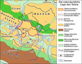
Its natural northern border is defined by the range of the Tempelhofer Berge, among them the Kreuzberg rising to 66 m (217 ft), along the southern bank of the Spree.
It is, however, disputed whether the Müggelberge hills, which are up to 115 m (377 ft) above sea level (NN), in southeast Berlin are part of the Teltow.
The gypsum hill is also of historic scientific interest, because it was here, in 1867, that the first borehole in the world to reach a depth of 1,000 metres (3,300 ft) was drilled.
These deposits formed between the Elster and Saalian ice advances, when the Elbe flowed northwards from the location of present-day Torgau and crossed the area of the Fläming which did not yet exist.
Because the Saale ice shoved the underlying sediments strongly, Tertiary deposits are found at the surface in places.
Today's Teltow plateau in Brandenburg-Berlin was formed around 20,000 years ago during the Brandenburg stage of Weichsel glaciation.
The Weichsel ice sheet pushed southwards right over the Teltow before reaching the northern edge of the Baruth Urstromtal, the limit of its expansion to the south.