Terai
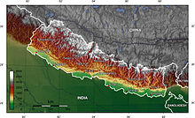
The Terai or Tarai is a lowland region in parts of southern Nepal and northern India that lies to the south of the outer foothills of the Himalayas, the Sivalik Hills and north of the Indo-Gangetic Plain.
This lowland belt is characterised by tall grasslands, scrub savannah, sal forests and clay rich swamps.
In North India, the Terai spreads from the Yamuna River eastward across Haryana, Uttarakhand, Uttar Pradesh, Bihar and West Bengal.
[7] The Terai is crossed by the large perennial Himalayan rivers Yamuna, Ganges, Sarda, Karnali, Narayani and Kosi that have each built alluvial fans covering thousands of square kilometres below their exits from the hills.
The geological structure of the region consists of old and new alluvium, both of which constitute alluvial deposits of mainly sand, clay, silt, gravels and coarse fragments.
[2] With deforestation and cultivation increasing, a permeable mixture of gravel, boulders and sand evolves, which leads to a sinking water table.
[14] From north-west to south-east these valleys are: The Outer Terai begins south of the Sivalik Hills and extends to the Indo-Gangetic Plain.
Further east, the Outer Terai comprises the Kapilvastu, Rupandehi, Nawalparasi, Parsa, Bara, Rautahat, Sarlahi, Mahottari, Dhanusa, Siraha, Saptari, Sunsari, Morang and Jhapa Districts.
[15] Several protected areas were established in the Terai since the late 1950s: Based on the Köppen–Geiger climate classification system, the Nepal Terai experiences a tropical savanna climate type with dry winters and hot summers, a mean annual temperature of 20–28 °C (68–82 °F), a mean annual rainfall of 1,600–1,800 mm (63–71 in) in the west and 2,500–3,000 mm (98–118 in) in the east.
[27] Pahari people from the mid-hills including Bahun, Chhetri and Newar moved to the plains in search of arable land.
High caste migrants from the hills and traditional Tharu landlords who own agriculturally productive land constitute the upper level of the economic hierarchy.
[32] The Muslim invasion of northern India during the 14th century forced Hindu and Buddhist people to seek refuge from religious persecution.
Rajput nobles and their entourage migrated to the Himalayan foothills and gained control over the region from Kashmir to the eastern Terai during the following three centuries.
[39] Until the mid 18th century, the Nepal Terai was divided into several smaller kingdoms, and the forests and wild places were, largely, left undisturbed.
[44] The far-western and mid-western regions of the Nepal Terai (called 'Naya Muluk', or ‘new country’) lay on the northern periphery of the Awadh dynasty.
[15] The Indian Terai remained largely uninhabited until the end of the 19th century, as it was arduous and dangerous to penetrate the dense marsh- and malaria-filled jungle with its predators.
[46] Dacoit gangs retreated to the Terai jungles, and the area was considered lawless and wild by the British, who sought control of the region's valuable timber reserves.
[49] Between 1961 and 1991, the annual population growth in the Terai was higher than the national average, which indicates that migration from abroad occurred at a large scale.
[57][58] After the 2008 Nepalese Constituent Assembly election, Indian politicians kept on trying to secure strategic interests in the Nepal Terai, such as over hydropower energy, development projects, business and trade.
[62] Major crops include rice, wheat, maize, potato, peas, lentil, mustard, sugar cane, ginger, turmeric, cardamom, garlic and chili.