Terrain-following radar
The term nap-of-the-earth flight may also apply but is more commonly used in relation to low-flying military helicopters, which typically do not use terrain-following radar.
It was first built in production form starting in 1959 by Ferranti for use with the TSR-2 aircraft, flying for the first time in an English Electric Canberra testbed in 1962.
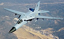
[2][3] While the TSR-2 project was ultimately abandoned, the concept was widely deployed in 1960s and 70s strike aircraft and interdictors, including the General Dynamics F-111, Panavia Tornado and Sukhoi Su-24 "Fencer".
The wider introduction of stealth aircraft technologies through the 1990s has led to a reduction in low-altitude flight as a solution to the problem of avoiding anti-aircraft weapons and the technique is no longer common.
[6] At the same time that the radar is sending out pulses, a function generator is producing a varying voltage representing a preferred manoeuvring curve.
To guide the aircraft, a series of these measurements are taken over the period of one complete vertical scan out to some maximum distance on the order of 10 kilometres (6.2 mi).
That voltage is a representation of the change in pitch angle the aircraft needs to fly at to keep itself at the desired clearance altitude above the terrain while manoeuvring at the selected load factor.
To address this, real-world units had an additional term that was applied that caused the aircraft to climb more rapidly against larger displacements.
[9] It was, however, accurate enough to produce a low-resolution map-like display of the ground below the aircraft, leading to the wartime development of the H2S radar.
In the case of the Lightning, the monopulse signal was used to accurately measure the horizontal angle, in order to allow the AIRPASS computer to plot an efficient intercept course at long range.
[12] Additionally, the system read turn rates from the instruments and moved the scanning pattern further left or right to measure the terrain where the aircraft would be in the future.
The tests were carried out from RAF Turnhouse at the Edinburgh Airport, close to Ferranti's radar development site in the city.
The pilot followed the computed path by pitching until the aircraft's velocity vector indicator, a small ring, was centred around the dot.
In tests, the pilots very quickly became confident in the system and were happy to fly it at the minimum clearance setting even in bad weather.
It was also found to property guide over artificial objects like the television antennas at Cairn O' Mounth and the Kirk o' Shotts transmitting station, bridges over the River Forth, and overhead power lines.
[5] In spite of the early start of Cornell's work, for reasons that are not well recorded, further development in the US ended for a time with the concept in a semi-complete form.
This changed dramatically after the 1960 U-2 incident, which led to the rapid switch from high-altitude flying over the USSR to the low-altitude "penetrator" approach.
In contrast to Ferranti's design, the APQ-110 offered several additional controls, including a ride quality setting for "hard", "soft" and "medium" that changed the G force of the calculated curve's descent profile from 0.25 to 1 G, while always allowing a maximum 3 G pullup.
Unhappiness with this state of affairs led the RAF to begin discussions with their French counterparts and the emergence of the BAC/Dassault AFVG, an aircraft very similar to the F-111.
[17] The next year, the UK government began negotiations with a wider selection of countries, leading eventually to the Panavia Tornado.
Terrain following radar is primarily used by military strike aircraft, to enable flight at very low altitudes (sometimes below 100 feet/30 metres) and high speeds.
However, radar emissions can be detected by enemy anti-aircraft systems with relative ease once there is no covering terrain, allowing the aircraft to be targeted.
The use of terrain-following radar is therefore a compromise between the increased survivability due to terrain masking and the ease with which the aircraft can be targeted if it is seen.
On aircraft with more than one crew, the radar is normally used by the navigator and this allows the pilot to focus on other aspects of the flight besides the extremely intensive task of low flying itself.
However, more modern aircraft such as the Rafale with phased array radars have a single antenna that can be used to look forward and at the ground, by electronically steering the beams.
Systems are now available that mount to commercial UAV's, allowing the carriage of Ground Penetrating Radar or magnetometry sensors for sub-surface survey.