Interferometric synthetic-aperture radar
This geodetic method uses two or more synthetic aperture radar (SAR) images to generate maps of surface deformation or digital elevation, using differences in the phase of the waves returning to the satellite[1][2][3] or aircraft.
Importantly though, it is consistent – provided nothing on the ground changes the contributions from each target should sum identically each time, and hence be removed from the interferogram.
The longer the baseline, the smaller the topographic height needed to produce a fringe of phase change – known as the altitude of ambiguity.
In the two-pass method, elevation data from an externally derived DEM is used in conjunction with the orbital information to calculate the phase contribution.
In the three-pass method two images acquired a short time apart are used to create an interferogram, which is assumed to have no deformation signal and therefore represent the topographic contribution.
There is also a geometric constraint on the maximum length of the baseline – the difference in viewing angles must not cause phase to change over the width of one pixel by more than a wavelength.
Persistent or permanent scatterer techniques are a relatively recent development from conventional InSAR, and rely on studying pixels which remain coherent over a sequence of interferograms.
In 1999, researchers at Politecnico di Milano, Italy, developed a new multi-image approach in which one searches the stack of images for objects on the ground providing consistent and stable radar reflections back to the satellite.
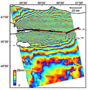
Commonly such techniques are most useful in urban areas with many permanent structures, for example the PSI studies of European geohazard sites undertaken by the Terrafirma project.
[5] The Terrafirma project provides a ground motion hazard information service, distributed throughout Europe via national geological surveys and institutions.
The objective of this service is to help save lives, improve safety, and reduce economic loss through the use of state-of-the-art PSI information.
Over the last 9 years this service has supplied information relating to urban subsidence and uplift, slope stability and landslides, seismic and volcanic deformation, coastlines and flood plains.
The processing chain used to produce interferograms varies according to the software used and the precise application but will usually include some combination of the following steps.
The interferogram is then formed by cross-multiplication of each pixel in the two images, and the interferometric phase due to the curvature of the Earth is removed, a process referred to as flattening.
For deformation applications a DEM can be used in conjunction with the baseline data to simulate the contribution of the topography to the interferometric phase, this can then be removed from the interferogram.
For most quantitative applications the consecutive fringes present in the interferogram will then have to be unwrapped, which involves interpolating over the 0 to 2π phase jumps to produce a continuous deformation field.
The final processing stage involves geocoding the image, which resamples the interferogram from the acquisition geometry (related to direction of satellite path) into the desired geographic projection.
While the majority of InSAR to date has utilized the C-band sensors, recent missions such as the ALOS PALSAR, TerraSAR-X and COSMO-SkyMed are expanding the available data in the L- and X-band.
Airborne InSAR data acquisition systems are built by companies such as the American Intermap, the German AeroSensing, and the Brazilian OrbiSat.
[6] Terrestrial or ground-based SAR interferometry (TInSAR or GBInSAR) is a remote sensing technique for the displacement monitoring of slopes,[7] rock scarps, volcanoes, landslides, buildings, infrastructures etc.
The accuracy in the displacement measurement is of the same order of magnitude as the EM wavelength and depends also on the specific local and atmospheric conditions.
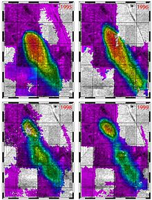
They found that the publication trends follow a power model, indicating that despite its inception in the last century, InSAR is a growing topical issue and has become established as a valuable tool for studying landslides.
Interferograms can be used to produce digital elevation maps (DEMs) using the stereoscopic effect caused by slight differences in observation position between the two images.
A second approach is to use two antennas mounted some distance apart on the same platform, and acquire the images at the same time, which ensures no atmospheric or deformation signals are present.