Kīlauea
Kīlauea erupted nearly continuously from vents on its eastern rift zone between January 1983 and April 2018, causing major property damage, including the destruction in 1990 of the towns of Kalapana and Kaimū along with the community's renowned black sand beach.
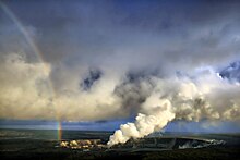
[10] Kīlauea's activity has a major impact on its mountainside ecology, where plant growth is often interrupted by fresh tephra and drifting volcanic sulfur dioxide, producing acid rains particularly in a barren area south of its southwestern rift zone known as the Kaʻū Desert.
Kīlauea has a large summit caldera named Kaluapele (the pit of Pele),[18] measuring 4 by 3.2 km (2.5 by 2.0 mi) with walls up to 120 m (400 ft) high, breached by lava flows on the southwestern side.
Tectonic extension along them is causing Kīlauea's bulk to slowly slide seaward off its southern flank at a rate of about 6 to 10 cm (2 to 4 in) per year, centered on a basal décollement fault 7 to 9 km (4 to 6 mi) beneath the volcano's surface.
[31] The eastern rift zone is a dominant feature on the volcano; it is almost entirely covered in lava from the last 400 years, and at its crest near the summit is 2 to 4 km (1 to 2 mi) wide.
[22]Geologists dated and documented dozens of major eruptions over the volcano's history, bridging the gap between Kīlauea's oldest known rock and written records and historical observation.
Evidence suggests the existence of an active eruptive center at this time, termed the Powers Caldera, whose fractures and faults lie 2 km (1 mi) outside Kaluapele.
At least 1,200 years ago, lava from the Powers Caldera overtopped its rim and solidified the structure; this was followed by a period of voluminous tube-fed pāhoehoe flows from the summit.
[40] The eruption lasted for 26 days and produced an estimated 205 to 265 million cubic meters of lava;[24] the light generated by the event was so intense that one could reportedly read a newspaper in Hilo at night, 30 km (19 mi) away.
This activity eventually gave way to the construction of Mauna Iki, building up the lava shield on the volcano's southwest rift zone over eight months.
On May 3, 2018, new fissures formed, and lava began erupting in lower Puna after a 5.0 earthquake earlier in the day, causing evacuations of the Leilani Estates and Lanipuna Gardens subdivisions.
[86] On August 23, 2021, the Hawaiian Volcano Observatory raised Kīlauea's alert status from "Yellow/Advisory" to "Orange/Watch" due to an earthquake swarm and a concurrent increase in ground deformation at the summit.
[88] The Hawaiian Volcano Observatory recorded increased earthquake activity and changes in ground deformation patterns at Kīlauea's summit at about noon local time on September 29, 2021.
Overflight measurements from October 5, 2022, indicated that 111 million m3 (29 billion U.S. gal) of lava had been effused, and that the floor of Halemaʻumaʻu had risen 143 meters (469 ft), since the beginning of this eruption.
While oral history has been used to confirm previously known geologic data, it can be used to assess hazards surrounding an eruption, in addition to guiding the rehabilitation of affected communities.
[109] Kīlauea's ecological community is further threatened by the volcano itself;[23] lava flows often overrun and incinerate forest sections, while ash smothers local plant life.
[110] Kīlauea's bulk affects local climate through the influence of trade winds coming predominantly from the northeast, which, when squeezed upwards by the volcano's height, result in a moister windward side and an arid leeward flank.
[112] The park hosts many bird species, including the ʻapapane (Himatione sanguinea); ʻamakihi (Hemignathus virens); iʻiwi (Vestiaria coccinea); ‘ōma’o (Myadestes obscurus), ʻelepaio (Chasiempis sp.
); and the endangered ʻakepa (Loxops coccineus), ʻakiapolaʻau (Hemignathus munroi), nēnē (Branta sandvicensis), ʻuaʻu (Pterodroma sandwichensis), and ʻio (Buteo solitarius) species.
Although not a "true" desert (rainfall there exceeds the maximum 1,000 mm (39 in) a year), precipitation mixing with drifting volcanic sulfur dioxide forms acid rain with a pH as low as 3.4, greatly hampering plant growth.
At 27,785 acres (11,244 ha), Wao Kele o Puna is Hawaiʻi's largest lowland wet forest reserve, and is home to rare plant species including hāpuʻu ferns (Cibotium spp.
ʻOpeʻapeʻa (Lasiurus cinereus semotus) ʻio (Buteo solitarius), common ʻamakihi (Hemignathus virens), and nananana makakiʻi (Theridion grallator) live in the trees.
[121] Early settlements had a major impact on the local ecosystem, and caused many extinctions, particularly bird species, while introducing foreign plants and animals and increasing erosion rates.
Kamapuaʻa, hard-pressed by Pele's ability to make lava spout from the ground at will, covered the feature, a favorite residence of the goddess, with fern fronds.
[127] Another missionary, C. S. Stewart, U.S.N., wrote of it in his journal A Residence in the Sandwich Island, which Letitia Elizabeth Landon quoted from in the notes to her poetical illustration to an engraving of a painting by William Ellis after F Howard, The Volcano of Ki-Rau-E-A in Fisher's Drawing Room Scrap Book, 1832.
After witnessing the devastation of the 1908 Messina earthquake near Mount Etna in Italy, he declared that systematic volcanic and seismic study was required, and chose Kīlauea as the initial site.
[134] In October 2019, January 2020, and December 2020, USGFS volcanologists used a drone to study gases inside the water lake at the summit, as it was too dangerous for humans to approach.
After the 2007 eruption ended, they analyzed thousands of events from seismic sensors, GPS stations, and lake height observations, including variables such as temperature and gas bubble density.
Thurston, who owned the Honolulu Advertiser newspaper, printed editorials in favor of the idea; by 1911 Governor Walter F. Frear had proposed a draft bill to create "Kilauea National Park".
Following endorsements from John Muir, Henry Cabot Lodge, and former President Theodore Roosevelt (in opposition to local ranchers) and several legislative attempts introduced by delegate Jonah Kūhiō Kalanianaʻole, House Resolution 9525 was signed into law by Woodrow Wilson on August 1, 1916.