Teton Dam
Interest in building a dam in the eastern Snake River Plain had arisen for many years to control spring runoff and provide a more constant water supply in the summer.
[4] Lack of funding and site preparation work and questions surrounding the required environmental impact statement stalled the project.
They argued that damming a wild and scenic river would result in the destruction of its trout fishery and other wildlife habitat and "replace a unique resource with a vulgar one."
The suit questioned the economic return on the investment, the bureau's compliance with the National Environmental Policy Act, and the geologic soundness of the dam's location.
[8] Concerns over the seismic conditions of the dam site delayed the bid process pending further review by the Department of the Interior.
[8] The eastern Snake River Plain is almost entirely underlain by basalt erupted from large shield volcanos on top of rhyolitic ash-flow tuff and ignimbrites.
[11] Test cores, drilled by engineers and geologists employed by the Bureau of Reclamation, showed that the canyon rock at the dam site is highly fissured and unstable, particularly on the right side (as one faces the direction of flow).
In addition, an investigation of the area by geologists of the U.S. Geologic Survey indicated that it was seismically active; five earthquakes had occurred within 30 miles (50 km) of the dam site in the previous five years, two of which had been of significant magnitude.
This information was provided to the Bureau of Reclamation in a memorandum, but the geologists' concerns were considerably watered down in the 6-month redrafting process before the USGS sent the final version of the memo to the USBR in July 1973.
[11] Later, the report of a committee of the House of Representatives, which investigated the dam's collapse, felt that the discovery of the caves should have been sufficient for the Bureau of Reclamation to doubt its ability to fill them in with grout, but this did not happen.
However, snows were heavy that winter, and five months later, the project's construction engineer requested permission to double the filling rate to deal with the additional spring run-off, while continuing to inspect for leaks and monitor the groundwater.
A month later, though monitoring showed that groundwater was flowing a thousand times faster than had been originally anticipated, the filling rate was doubled again, to 4 feet (1.2 m) a day.
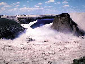
[citation needed] On Saturday, June 5, 1976, at 7:30 am MDT, a muddy leak appeared, suggesting sediment was in the water, but engineers did not believe there was a problem.
The first was the flow of water under highly erodible and unprotected fill, through joints in unsealed rock beneath the grout cap and development of an erosion tunnel.
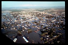
When the dam failed, the flood struck several communities immediately downstream, particularly Wilford at the terminus of the canyon, Sugar City, Salem, Hibbard, and Rexburg.
The flood waters traveled west along the route of the Henrys Fork of the Snake River, around both sides of the Menan Buttes, damaging the community of Roberts.
[24] That dam held and the flood was effectively over, but tens of thousands of acres of land near the river were stripped of fertile topsoil.
[7] The force of the failure destroyed the lower part of the Teton River, washing away riparian zones and reducing the canyon walls.
The force of the water and excessive sediment also damaged stream habitat in the Snake River and some tributaries, as far downstream as the Fort Hall bottoms.
Within a week of the disaster, President Gerald Ford requested a $200 million appropriation for initial payments for damages, without assigning responsibility for Teton Dam's failure.