Thallichtenberg
Down in the dale, the village site abuts the Pfeffelbach (brook), which here turns from its south-to-north direction of flow towards the east, forming a narrow gorge between the Burgberg and the Niederberg within Ruthweiler’s limits.
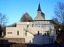
Also found at Lichtenberg Castle are the Evangelical church for the villages of Thallichtenberg and Ruthweiler, the youth hostel, the herb garden, a well visited inn with a nice view and a registry office.
[5] In the late New Stone Age, nomads were found in the area around what is now Thallichtenberg, as archaeological finds from neighbouring places bear witness.
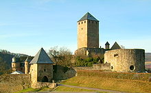
When the Counts of Veldenz were given their jobs as Vögte over the so-called Remigiusland as far back as the early 12th century, they began, unlawfully, to build a castle in this domain that belonged to the Abbey of Saint-Remi in Reims, against which misdeed the abbot fought back by registering a protest with Holy Roman Emperor Frederick II.
The actual protest document is lost to history; however, a text of the Emperor's ruling on the matter, handed down in Basel in 1214, has survived.
In part, this reads: “… quod nos auctoritate regia castrum Lichtenberg, quod comes de Veldenzen in allodio Sancti Remigii Remensis, … violenter et iniuxte construxit, juste destruere debeamus.” (“By our kingly authority, we are forced to lawfully tear down Castle Lichtenberg, which the Count of Veldenz has forcibly and wrongfully built on Saint Remigius’s property.”).
The Count of Veldenz in this case was Gerlach IV, and he did not bow to the Emperor's ruling, and hence, the castle remained standing.
[8] From Zweibrücken times it is clear that only the part of Thallichtenberg that lay on the brook's left bank was counted as one of the villages within the Burgfrieden (the castle's sovereign area).
On the unprotected south side arose a broad bailey ringed with a high outer wall with a battlement parapet.
At the beginning of the Thirty Years' War, craftsmen and farmers from the castle area built, shortly before Spanish troops advanced in 1620, the so-called Hufeisenturm (“Horseshoe Tower”) with particularly thick walls that were supposed to stand up even to cannon balls.
While only a few of the inhabitants down below in the dale on the brook's right bank were the Burgmannen’s serfs, those living within the Burgfrieden continually had to perform compulsory labour for the lordship at the castle.
Thallichtenberg and the castle belonged at the time of French annexation beginning in 1801 to the Mairie (“Mayoralty”) of Burglichtenberg, the Department of Sarre, the Arrondissement of Birkenfeld and the Canton of Kusel.
In 1935, after a referendum on the question, the Saar, now known as the “Saarland”, chose to rejoin Germany where, by this time, Adolf Hitler and the Nazis had taken over and established the Third Reich.
For its part, the village of Thallichtenberg was characterized by agriculture, though already in the 18th and 19th centuries, men were working in mines and quarries in the area.
First and foremost, Thallichtenberg today is a residential community for people from all walks of life, most of whom earn their livelihoods outside the village.
This fortification was held to be a castle on a light (in colour, that is) mountain, or Burg auf dem lichten Berg in German.
Another document in 1445 read “zu Dalen”, and indeed, it is still customary nowadays to refer to Thallichtenberg as de Dal in the local speech.
The distinction between Thallichtenberg and Burglichtenberg became necessary once a new village had arisen within the castle ruins in the 19th century, and then also because for a long while, the seat of a Prussian Amtsbezirk was there.
[13] Within what are today Thallichtenberg's municipal limits once lay a whole series of villages, most of which vanished even before the Thirty Years' War.
In 1371, a village named Berweiler (Berwilre) was mentioned, which was described in 1588 by Johannes Hoffmann as “ehemalige Dorfstadt” (“former village-town”); it might have lain west of Thallichtenberg.
Indeed, the name Wadenau appeared quite often in documents from the Counts of Veldenz; it was so nearby that knights from the castle long made it their residence.
Buried at the Thallichtenberg Jewish graveyard, which nowadays stands under monumental protection, were Jews from the villages in the castle area and also from the town of Kusel.
[1] The German blazon reads: In geteiltem Schild oben in Silber ein wachsender, rotbewehrter und -bezungter, blauer Löwe, unten von Grün und Silber dreifach geteilt, auf den grünen Balken fünf silberne Kugeln 3:2.
The charge in the escutcheon’s upper field, the demilion, is the heraldic device once borne by the Counts of Veldenz, the local rulers until 1444.
[21] At the time of the feudal lordship, the villagers were to a great extent dependent on the castle, which was for them an important basis on which livelihoods were earned.
Even today, it is regarded as an important income earner, although now its use as such comes from tourism and the many thousands of visitors that that draws to the castle each year.
Classes were only sparsely attended for the children had to walk a long, arduous way to school and back each day, unless they happened to live right at the castle.
It was also at this time that Dennweiler, Frohnbach and Körborn found themselves in the Kingdom of Bavaria anyway as a result of what had been decided at the Congress of Vienna.
In 1835, the then Amtsbürgermeister, named Sohns, bought the former Lichtenberg Castle scrivener's building at auction to set up a school within it for the pupils from Burglichtenberg, Thallichtenberg and Ruthweiler.
Since Thallichtenberg was now also asserting ownership rights on the schoolhouse in Ruthweiler and was demanding a financial adjustment, a court case ensued that was put to an end only after the Second World War by a compromise.