The Atlas of Middle-earth
It provides many maps at different levels of detail, from whole lands to cities and individual buildings, and of major events like the Battle of the Pelennor Fields.
The atlas has been warmly received by Tolkien scholars, who have called it both authorized and magisterial, providing in particular a comprehensive set of thematic maps of Middle-earth.
[3][2] Middle-earth is the fictional world created by the philologist and fantasy author J. R. R. Tolkien and presented in his bestselling books The Hobbit (1937) and The Lord of the Rings (1954–1955).
[14] Michael Brisbois, also in Tolkien Studies, describes the atlas as "authorized",[15] while the cartographers Ina Habermann and Nikolaus Kuhn take Fonstad's maps as defining Middle-earth's geography.
[16] The Tolkien scholar Luke Shelton calls the book the more popular of the two atlases of Middle-earth, the other being Barbara Strachey's more specific Journeys of Frodo.
He gives as an instance the work that she did to make the journey of Thorin's company in The Hobbit consistent with the map, something that Tolkien found himself unable to do.
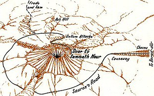
Danielson writes that in addition, Fonstad created "the most comprehensive set" of thematic maps of Middle-earth, presenting geographic data including political boundaries, climate, population density, and the routes of characters or armies.