The Crack (trail)
[2] Hikers will continue on the lakeshore which has many areas usable for swimming for the next 0.8 kilometres.
At the start, they will be going through steep, heavily forested hills, and they will begin to notice patches of rocks.
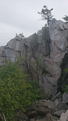
[3] After 0.6 kilometres of going up, the forest will have finished as the ground will have become quartzite by this point, so the hiker would have a view of surrounding mountains.
[4] After 0.4 kilometres, they will encounter The Crack, a valley in the mountain filled with boulders created by boulders fallen from a slicing cliff, resembling a crack in the mountains, which the trail is named after.
[11] After climbing through the quartzite boulder covered area for 0.2 kilometres, the hiker will reach the summit (46°03′41″N 81°20′54″W / 46.0614°N 81.3482°W / 46.0614; -81.3482 (The Crack Trail, summit)), where they will be greeted by a panoramic view of Killarney Lake, OSA Lake, the Georgian Bay, and the surrounding mountains.