The Wiggle
The path generally follows the historical route of the long since paved-over Sans Souci Valley watercourse, winding through the Lower Haight neighborhood toward the Panhandle section of Golden Gate Park.
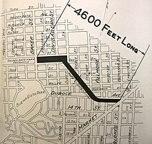
It then moves in a zig-zag toward the northwest along Duboce Avenue, Steiner, Waller, Pierce, Haight, Scott, and Fell Streets to the Panhandle Bikeway, 215 feet (66 m) above sea level.
[4] Over thousands of years, the gentle valley bottom was formed through a process of gradual erosion of the soft, crumbly serpentine.
An Indian village called Chutchui existed in the vicinity of Mission Dolores near the area where The Wiggle meets Market Street.
The footpath went toward what is now the Panhandle and then connected to the associated village Petlenuc at the northern tip of the San Francisco Peninsula near the current site of Crissy Field.
In the 1870s, a grid of streets was imposed in its place, one retaining the old road's name, across a newly formed neighborhood with all the sandy hills and steep gullies filled or scraped flat.
"[10] The "stop-in" protest, along with 100 cyclist comments at a public meeting, brought a halt to the police crackdown at the time,[7] but was unsuccessful in permanently changing city policy after a proposed City ordinance by Supervisor John Avalos to legalize bicyclists treating stop signs as yield signs was vetoed by Mayor Ed Lee.