The Thumb
The counties that constitute the Thumb form the peninsula that stretches northward into Lake Huron and Saginaw Bay.
The Thumb region is very flat with fertile soil, the reason for its historical role as a chiefly agricultural area.
Major agricultural products include sugar beets, navy beans,[1] corn, fruits, and fish from Saginaw Bay and Lake Huron.
The I-69 International Trade Corridor is a strategic commercial gateway between the Midwestern United States and Ontario, Canada, with multi-modal transportation infrastructure that offers a wide range of distribution options.
The county is surrounded on three sides by water – Saginaw Bay and Lake Huron, and has over 90 miles (140 km) of shoreline, from White Rock on Lake Huron to Sebewaing on Saginaw Bay, and more shoreline parks than any other county in the state.
The origin of the name of the county is often disputed, but it may have derived from the French words la pierre, meaning "the stone".
This name could be a reference to the rounded stones, or flint pebbles, found in the rivers and streams throughout the area.
St. Clair County has the largest population in the Thumb, and is considered part of the Metro Detroit MSA.
Many residents farther north in the Thumb, especially Sanilac County, travel to Port Huron for shopping and work.
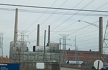
Industries such as sugar refining and ethanol processing, as well as growing various grains and beans, make up most of the economy.
Tuscola County is economically tied to the surrounding region as well as to the Saginaw, Bay City, and Flint areas.
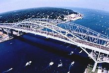
The namesake Blue Water Bridge spans the St. Clair River, connecting Port Huron to Sarnia, Ontario.
A similar name, "Blue Water Country," is used to describe the same region on the Canadian side.
Many of these new settlers were sent into the area by the British from Canada in an effort to establish their dominance over the Great Lakes.
In 1783, control of the Thumb was officially transferred to the newly formed United States, after the American Revolution and by the Treaty of Paris.
The British were a dominant influence until after the War of 1812, when the northern border was firmly defined and this area came under US control.
The US organized the Northwest Territory, and American settlement of Michigan and the Thumb was well underway by the mid-19th century.
Settlers migrated west from New York and New England into Ohio and Michigan, seeking new territory.
As a result of this history, the land was settled primarily by people of ethnic English and Scots-Irish descent; many arrived from Canada.
Some local radio stations have featured polka shows, and various ethnic festivals, such as the Polkafest, in Kinde, are representative of Eastern European cultures.
In the early years, Europeans encountered and traded with people of the Fox and Sauk tribes, already living in the area for centuries.
All native Thumb area tribes are members of the Algonquian peoples, a large language family.
Other tribes who migrated later into the area included the Wyandot (Huron), an Iroquoian language-speaking people; and the Ottawa.
District 9 – Northern Macomb, and all of St Clair, Lapeer, Sanilac, Huron, and Tuscola counties.
83rd District – City of Port Huron, the Townships of Fort Gratiot and Burtchville, and all of Sanilac County.
The Thumb's other half is covered by area code 810, which takes in most of Sanilac, Lapeer, Genesee and Saint Clair counties.