Public Land Survey System
Today, the BLM controls the survey, sale, and settling of lands acquired by the United States.
With little power to tax, the federal government decided to use the sale of the Western Territories to pay off war debt.
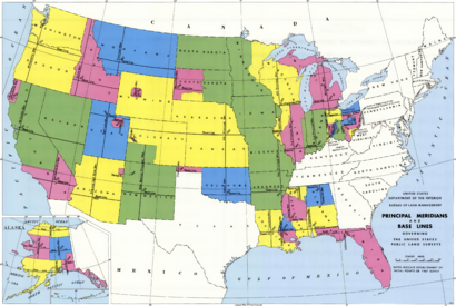
The PLSS has been expanded and slightly modified by Letters of Instruction and Manuals of Instruction, issued by the General Land Office and the Bureau of Land Management, and is still in use in most of the states west of Pennsylvania, south to Florida, Alabama, and Mississippi, west to the Pacific Ocean, and north into the Arctic in Alaska.
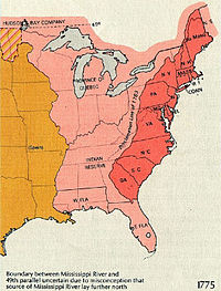
The original colonies (including their derivatives Maine, Vermont, Tennessee, Kentucky and West Virginia) continued the British system of metes and bounds.
The metes and bounds system was used to describe a town of a generally rectangular shape, 4 to 6 miles (6.4 to 9.7 km) on a side.
A National Historic Landmark marker commemorating the site lies on the side of a state highway, exactly 1,112 feet (339 m) to the north of the point.
The early surveying, particularly in Ohio, was performed with more speed than care, with the result that many of the oldest townships and sections vary considerably from their prescribed shape and area.
The federal government typically surveyed only to this quarter-section level, the subdivision of smaller parcels being carried out subsequently by private surveyors after original sale.
Because the survey design is two-dimensional (rectangular), while the actual Earth is three-dimensional (approximately spherical and topographically), adjustments to land areas must be made periodically to prevent error propagation; not all sections can be one square mile nor can all townships be exactly 36 square miles.
But it is a physical impossibility to meet this condition and still maintain a rectangular land grid, because such lines converge on the north pole.
This method accommodates the curvature problem within a township and also allows for any errors made during the surveying—which were nearly unavoidable because of the physical difficulty of the work and the crude equipment used—without overly compromising the basic rectangular nature of the system as a whole.
Thus, for example, the description "T1SR20E S13 MDM" reads as follows: Township 1 South, Range 20 East, Section 13, Mount Diablo Meridian.
Numbering in this pattern ensures that numerically sequential sections within the same township are physically adjacent and share colinear boundaries.
There were two chainmen, one at each end, who physically made the measurements, one of them typically also acting as "compassman" to establish the correct bearing at each chain placement.
In forested areas, it was essential for rapid progress and accuracy that the lead chainman follow the correct bearing at all times, since no straightening of the chain was possible without backtracking around trees and re-measuring.
In areas where measuring by chain was not possible, such as extremely steep terrain or water obstructions, distances were calculated by triangulation.
Monumentation is the establishment of permanent on-the-ground objects that mark exact locations of surveyed points and lines.
It was not uncommon for squatters or homesteaders to destroy corner monuments if they felt the patenting of the land would threaten their residence on it.
Witnesses can be trees, rocks, or trenches dug in the ground; their exact locations relative to the corner, and the markings made on them, are also recorded in the surveyor's official fieldnotes.
On the exposed wood of the blaze, surveyors were required to inscribe, with wood chisels, township, range and section information, on typically either two or four bearing trees, if they were within some reasonable distance of the corner (unspecified early on but later set at a maximum of 3 chains (178 feet, 60 meters) away).
The following table indicates some distance and area conversions in the PLSS: Based on the BLM manual's 1973 publication date, and the reference to Clarke's Spheroid of 1866 in section 2-82, the coordinates listed are believed to be in the NAD27 datum.
If the railway ran predominantly east and west, a 10-mile (16 km) range of one square mile sections was allotted on each side of the 400-foot (120 m) right-of-way.
If the railway ran predominantly north and south, a 10-mile (16 km) township of one square mile sections was allotted on each side of the 400-foot (120 m) right-of-way.
[9] The various states and counties ignored, altered or amended this provision in their own ways, but the general (intended) effect was a guarantee that local schools would have an income and that the community schoolhouses would be centrally located for all children.
The most notorious, large scale, and costly fraud was perpetrated by the Benson Syndicate, operating primarily in California in the 1880s.
Occasionally, and more frequently in a metropolitan region's inner postwar suburbs than in outer areas, arterials are at approximately half-mile intervals.
This strictly regimented urban (or suburban) structure has coincided with the similarly strict practice of Euclidean zoning (named after the town of Euclid, Ohio, which won a 1926 Supreme Court case Village of Euclid, Ohio v. Ambler Realty Co., which established the constitutionality of zoning).
Among other things, the stock phrases "lower 40", "front 40", "back 40", and "40 acres and a mule", which are sometimes heard in American movies, reference the quarter-quarter section.
The phrase "40 acres and a mule" was the compensation apocryphally promised by the Freedmen's Bureau following the American Civil War.