Thomas Fire
It burned approximately 281,893 acres (440 sq mi; 114,078 ha) before being fully contained on January 12, 2018, making it the largest wildfire in modern California history at the time.
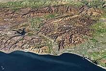
Firefighters concentrated on protecting the communities of Carpinteria and Montecito in the southern portion of the county as the fire burned in the foothills of the Santa Ynez Mountains where access was difficult.
[33] Much of Southern California experienced "the strongest and longest duration Santa Ana wind event we have seen so far this season", according to the National Weather Service.
[24] The region experienced an on-and-off Santa Ana wind event for a little over two weeks, which contributed to the Thomas Fire's persistent growths in size.
[37] While November is the typical beginning of the rainy season in California, the first measurable rain for the area fell on January 8, 2018, more than a month into the fire.
[43] That night, the small brush fire exploded in size and raced through the rugged mountain terrain that lies west of Santa Paula, between Ventura and Ojai.
[33][45] Soon after the fire had started, a second blaze was ignited nearly 30 minutes later, about 4 miles (6.4 km) to the north in Upper Ojai at the top of Koenigstein Road.
[14] Late on the night of December 4, the Thomas Fire reached the hillside neighborhoods of Clearpoint,[47] Ondulando,[48] and Skyline[49] in the city of Ventura and destroyed many single-family detached homes.
[24] On Tuesday, December 5, additional National Guard helicopters were brought in to fight the six largest wildfires burning in Southern California.
[1][36] On December 8, the Thomas Fire grew to 143,000 acres (58,000 ha) with containment of the wildfire increasing to 10%, after the Santa Ana winds died down.
[77] On December 21, all evacuation orders for Santa Barbara County were lifted, as firefighters continued to make progress on containing the wildfire.
[86] On December 27, the Thomas Fire experienced another small expansion in size on its northeastern flank, to 281,893 acres (114,078 ha), while containment of the wildfire increased to 91%.
[88] On the same day, a smoldering area within the western edge of the Thomas Fire's perimeter, near Gibraltar Road, flared up, sending smoke over Santa Barbara.
[89] On December 30, incident command was transferred to a local team headed by the Los Padres National Forest staff, and the Thomas Fire remained at 92% containment.
[92] The storm intensified on the following day, with at least four inches (100 mm) of rain falling over the two-day period, before the rainfall ended on January 9, causing several major mudflows.
[95][96] Afterward, Los Padres National Forest officials continued monitoring the burn area of the Thomas Fire for hotspots.
[97] Additionally, The Channel Islands Air National Guard 146th AW MAFFS unit was activated for airdrops and served as an incident command center for aerial operations.
[98] A total of ten strike teams from across the state of Oregon deployed to help California firefighters battle multiple massive blazes north of Los Angeles, including the Thomas Fire.
[115] Numerous single-family homes were destroyed along with the Hawaiian Village Apartments in the hills above downtown Ventura and 12 houses for guest workers of Limoneira Co. near Santa Paula.
The downtown Harbor View Apartments and the Vista del Mar hospital (a psychiatric facility) on the west side of Ventura were among the complexes that were heavily damaged.
[119][120] The transmission system which runs from Ventura County to Goleta had to be shut down to prevent further problems until Edison employees could safely access the area for inspections.
[62][63] Amtrak passenger rail service between Oxnard and San Luis Obispo on the Pacific Surfliner was suspended indefinitely when the fire reached the route along the Rincon north of Ventura.
[127] On Tuesday, December 5, the city of Ventura issued a precautionary boil-water advisory, because of the loss of pressure in the water system from power outages related to the fire.
[128] A similar warning was issued by the Casitas Municipal Water District which serves portions of the Ojai Valley and communities along the Rincon Coast from Ventura to the Santa Barbara County line.
During the alerts, authorities have recommended that people stay indoors, avoid driving in affected areas and drink plenty of fluids.
And that was the first indication that we had a real crisis happening.On Tuesday, December 5, 2017, at 10:45 p.m. PST, Governor Jerry Brown declared a state of emergency in Ventura County, due to the Thomas Fire.
Debris flows typically surge, as precipitation rate and sediment supply vary, hydraulic jumps occur, landslide dams in the channel form and collapse.
Upon exiting the steeper mountain canyon, as the stream gradient is reduced, the debris flow spreads laterally and begins to deposit larger particles on the alluvial fan.
It takes years for disturbed channels to achieve relative stability as bed load sediment adjusts and vegetation is reestablished.
[46][141] In March 2019, investigators determined that Southern California Edison’s equipment had sparked both ignitions that became the Thomas Fire, but in a settlement with public agencies, the utility did not admit fault.


Out of State Mutual Aid


