Thormanby
It lies on the A19 approximately halfway between Easingwold and Thirsk and about 14 miles (23 km) south east of the county town of Northallerton.
Before the Norman Conquest most of the land in the parish belonged to the manor of Earl Morcar, with a small areas owned by Arkil and Gamel.
Following Domesday the manor passed to the Crown and, along with the smaller areas of land, was granted to Robert Malet.
[2][5] It eventually passed into the Nevill family, lords of the manors of Sheriff Hutton and Raskelf, who held it until the 15th century.
[6][7] Most of the land in the village was owned by the Viscounts Downe of Wykeham, but much of this was sold in 1918 with the disposing of the Sessay Estate.
[2] William Page in his A History of the County of York North Riding states: "According to tradition there was once a castle here.
It is also said that in the rebellion of the Earl of Northumberland in 1569, the royal forces encamped on Thormanby Carr on their way to Maiden Bower near Topcliffe.
Residents opposed his application to convert the pub through a belief that the village needed a "focal point".
[11] The Thirsk and Malton branch of the North Eastern Railway passes through the parish, but there is no station here.
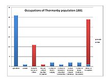
[13] The stacked column chart represents a simplified version of the 1881 occupational data, using the 24 'Orders' used in the published reports for 1881, plus an 'Unknown' category.
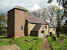
[14] The village church is dedicated to St Mary Magdalene and is a Grade II* listed building.
The Old Rectory is a Grade II Listed 18th-century Georgian residence, built in 1737 with a later addition of a schoolroom in 1786, and further alterations in 1837.
[17] At the north of the village, on the A19 near Birdforth Bridge, stands a Grade II-listed late 19th-century triangular cast iron mile post.