Three Fingered Jack
Formed during the Pleistocene epoch, the mountain consists mainly of basaltic andesite lava and was heavily glaciated in the past.
[10][11] The glacier resides at an unusually low altitude for the central Oregon Cascades it is protected by tall ridges to the south and west.
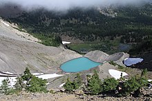
[14] Before September 1960, there was a partial breach of this moraine-dammed lake that covered an area of 12,000 square metres (3.0 acres) near the moraine's base.
[15] Local soil is thin, and it has been buried by a layer of weathered Holocene tephra from Three Fingered Jack, which has a maximum thickness of 3.3 feet (1 m).
[21] Other bird species found in the area consist of Eurasian three-toed woodpeckers, willow flycatchers, olive-sided flycatchers, tree swallows, Canada jays, Steller's jays, common ravens, Clark's nutcrackers, black-capped chickadees, mountain chickadees, chestnut-backed chickadees, red-breasted nuthatches, pygmy nuthatches, Eurasian treecreepers, American dippers, wrens, American robins, varied thrushes, hermit thrushes, Townsend's solitaires, golden-crowned kinglets, ruby-crowned kinglets, water pipits, blue-headed vireos, western tanagers, Cassin's finches, gray-crowned rosy finches, pine siskins, red crossbills, green-tailed towhees, dark-eyed juncos, white-crowned sparrows, golden-crowned sparrows, fox sparrows, and Lincoln's sparrows.
[10] South of Mount Jefferson, the High Cascades of Oregon consist of a broad ridge produced by shield volcano activity and eruptions from cinder cones.
Vents range from deeply eroded complexes to recently active volcanoes, with most of the region mantled by normally polarized rock produced within the past 730,000 years.
[29] Three Fingered Jack is part of a group of more than 30 large shield volcanoes and stratovolcanoes that form a segment of Pleistocene-to-Holocene-epoch volcanic vents that produced mafic lava (rich in magnesium and iron).
[31] The major edifice, which consists of light gray, basaltic andesite lava flow deposits, sits 1,000 feet (300 m) to the west of the first tephra cone.
It is highly eroded;[22][26] shaped like a sawtooth, it consists of tephra deposits supported by a vertical dike with a thickness of 10 feet (3.0 m).
The northern and southern flanks of Three Fingered Jack feature lava flows made of olivine and augite basalt.
Secondary volcanic craters produced lava flows and pyroclastic material, which traveled both north and south of the volcano.
Ervin McNeal, Phil Philbrook, Armin Furrer, Wilbur Watkins, Leo Harryman, and Ronald Sellars were the first to ascend Three Fingered Jack on September 3, 1923.
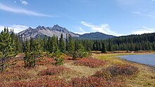
The Canyon Creek Meadows hiking trail begins at Jack Lake, progresses through the Mount Jefferson Wilderness, and runs for about 4.5 miles (7.2 km).
An additional connected hiking trail runs for another 3 miles (4.8 km) up the rocky glacial washout plain adjacent to the volcano, becoming steeper as it approaches Three Fingered Jack and gaining 1,400 feet (430 m) in elevation.
[19] The base can also be reached on Pacific Crest Trail which runs for 11.6 miles (18.7 km) round trip and offers views of the volcano and its summit lake.
[43] When Three Fingered Jack's face becomes foggy, climbers have become disoriented due to the low visibility conditions of climbing the mountain, requiring rescue.
[44][45] The summit can be quite dangerous due steep cliffs and poor rock quality which can result in footing and hand holds giving way without warning.