Thuringian Forest
The Thuringian Forest forms a continuous chain of ancient rounded mountains with steep slopes to both sides and poses ample difficulties in transit routing save through a few navigable passes.
Two more long-distance roads, Bundesstraßen 19 and 84, pass over the western parts of the range, while Bundesstraße 88 skirts the northern foothills between Eisenach and Geraberg.
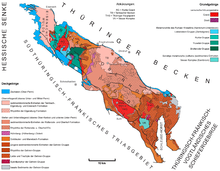
It consists of a large fault block in hercynian orientation, which consists from sandstones and conglomerates of Rotliegend age in its western parts (Eisenach trough), followed by granites and gneisses of the Ruhlaer Kristallin formation of early paleozoic origin which were uplifted in the Rotliegend era, and the conglomerates, sandstones, and abundant volcanic rocks (rhyolites and andesites) of the Oberhof trough.
[3] Ore deposits associated with the upthrust of the range have been of significant historical importance in the development of the region, for example, the metalworking tradition in Suhl[6] and the mining history of Ilmenau.
[7] The uplift of the horst-like fault block was part of the Saxonian tectonic processes and is understood as a long range effect of the Alpine orogeny.
These stretch especially wide on the northwestern edge of the Thuringian forest, where the landscape park of Altenstein Palace is located on one of the largest Zechstein reefs in Germany.
It was uplifted as one of the fault blocks in the Saxonian tectonic era[8] and is filled with Variscan molasses, named Eisenach formation after the location.
It consists mostly of monotonous sequences of reddish conglomerates representing a proximal alluvial fan which originated in debris flows from the Ruhla anticline.
They are named Ruhlaer Kristallin after the location and are according to Franz Kossmat considered part of the Central German Crystalline Zone, of which Odenwald and Spessart are also constituents.
Their relative ages have not been fully resolved yet, partly because the Oberhof trough had been a rift zone with intense tectonics and continual changes of the internal relief and of the main areas of deposition.
It is oriented roughly parallel to the Thuringian Forest and, while a separate structure, is geologically very similar to the latter, as it consists of the same rock types such as granite, hornfels, porphyrites, Rotliegend and Zechstein sediments, and thus forms part of the Variscan chain.
Humid air arrives mainly from the west, so that the western slopes and the crest of the chain experience the highest levels of precipitation.
As the Thuringian Forest forms a barrier to the main weather currents, erosion is strong and has led to a more pronounced relief than in many other of the European low mountain chains.
The Northwest Thuringian Forest comprises an area of about 70 km2 reaching heights up to 470 m (1,540 ft), hardly exceeding those of the adjacent Buntsandstein forelands to the southwest, but exhibiting a much more pronounced relief.
Notable summits include: The much larger natural region of Central Thuringian Forest with an area of about 850 km2, whose ridge rises mostly above 600 m (2,000 ft), is subdivided into several parts described below in their sequence from the north-west to the south-east.
This part, situated around the town of Ruhla north of the Rennsteig, is geologically formed by the basement rocks of the Ruhlaer Kristallin, consisting of granites, gneiss, and schist.
Notable summits include: Reaching until Tambach-Dietharz, the part of Thuringian forest around the town of Brotterode is geologically more heterogeneous than the region around Ruhla.
Notable summits include: The B 247 from Luisenthal via Oberhof and Zella-Mehlis to Suhl, which follows the Ohra to the north, a section along the Lichtenau to the south and finally the lower reaches of the Mühlwasser, together with the slightly more than 10 km long L 1028 road that runs parallel to it to the northwest separates this natural sub-division of the Thuringian Forest from the rest.
The adjacent Thuringian Slate Mountains form a geographically and geologically separate natural region, although they are often popularly referred to as a continuation of the former range.
As seen from there, all secondary crests towards the northeast and the southwest clearly originate from the main one and show even and gentle slopes, not counting the steep descent into the foreland.
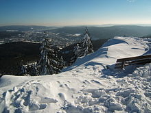
Notable summits include: Due to its geographical characteristics and the favourable climate, the Thuringian Forest is an important year-round tourist destination.