Vogelsberg
Emerging approximately 19 million years ago, the Vogelsberg is Central Europe's largest basalt formation, consisting of a multitude of layers that descend from their peak in ring-shaped terraces to the base.
The Vogelsberg lies in the county of Vogelsbergkreis, around 60 kilometres northeast of Frankfurt between the towns of Alsfeld, Fulda, Büdingen and Nidda.
To the northeast is the Knüll, to the east the Rhön, to the southeast the Spessart and to the southwest the low-lying Wetterau, which transitions to the South Hessian lowlands of the Rhine-Main region.
Its present appearance, which is reminiscent of a large flat, shield-shaped volcano with a central dome, is the result of an interplay of uplift processes and ablation acting on all sides.
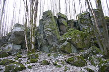
These volcanic products overlaid a basement of bunter sandstone and tertiary sands, in small areas in the east also rocks of the muschelkalk and keuper.
Erosion following the Miocene wore away the contiguous basalt nappes, which originally reached as far as the area of the Lower Main, back to isolated deposits in the central complex.
The division of the Vogelsberg into individual natural regions[3] is based, on the one hand, on the relief of the mountain range from its highest point towards the outside and, on the other hand, on its river catchments which radiate outwards: the catchments of the Eder (Schwalm), Lower Fulda (Schlitz and Lüder), Main (Kinzig and Nidda) and Lahn (Ohm).
The Oberwald (351.2) is the heart of the Vogelsberg and is entirely wooded; its outer boundary roughly follows the 600 metre contour line.
Because large areas of the original forest were cleared and the precipitation exceeds 1,000 mm per year, snow melt starts early.
The basaltic parts of the Lower Vogelsberg (350.1-350.5) range in height between 300 and 500 m, except on the western to southwestern fringes by the Wetterau where they descend below 200 m in places.
In addition to the woods that cover almost the entire natural region (including pine forests) there are extensive vegetation-free areas by the huge spoil tips of the potassium salt mine near Neuhof.
A lack of understanding of the particular hydrogeological and ecological situation in the Vogelsberg and excessive withdrawal resulted in springs drying up, cracks appearing in buildings and subsidence of the ground.
Moreover, there are regular RMV buses, the so-called Vulkan Express running from Büdingen, Stockheim, Nidda, Hungen, Mücke and Schlitz via Lauterbach at weekends to the heights of the Vogelsberg.
There is a large network of signposted cycleways in and around the Vogelsberg Nature Fitness Park around the highest summits and also 70 km of signed mountain bike routes.