Timeline of the 1995 Pacific hurricane season

[nb 2][2] Hurricane Barbara was the only tropical cyclone to exist in the Central Pacific in 1995, entering the region as a weak system near dissipation.

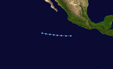
[6] On land, strong winds and severe flooding caused heavy damage and killed fifty-nine people in the Mexican state of Sinaloa.

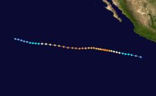
Flossie in August remained off the coast of Mexico but passed close enough to cause gusty winds and flooding rains; seven people died.

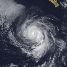
[10] In early September, Henriette made landfall at peak intensity on the southern tip of the Baja California peninsula before continuing westward out to sea; it caused moderate damage, but no known fatalities.

Figures for maximum sustained winds and position estimates are rounded to the nearest five units (knots, miles, or kilometers) and averaged over one minute, following National Hurricane Center practice.

A map of the short, straight, westward track of a tropical depression off the Pacific coast of Mexico
Storm path of Tropical Depression One-E
A map of the track of a hurricane off the Pacific coast of Mexico; moving northward at first, the hurricane gradually hooks to the west
Storm path of Hurricane Adolph
A photograph of a powerful hurricane off the Pacific coast of Mexico; it has a well-defined eye encircled by deep convection, with spiral bands arcing to the north
Satellite image of Hurricane Adolph shortly after becoming a major hurricane late on June 17
A map of the track of a hurricane over the Eastern Pacific Ocean; the hurricane generally moves west-northward for its entire life, except for a couple deviations westward
Storm path of Hurricane Barbara
A photograph of a powerful hurricane over the Eastern Pacific Ocean; the hurricane has a well-defined eye surrounded by a circular ring of deep convection, with several small rainbands spiraling outward
Satellite image of Hurricane Barbara at peak intensity early on July 14
A photograph of a hurricane off the Pacific coast of Mexico; the eye is obscured by clouds, and a long, wide spiral band of clouds begins on the northern flank before curving all the way around the hurricane
Satellite image of Hurricane Cosme shortly after being upgraded late on July 19
A map of the somewhat erratic track of a tropical storm off the Pacific coast of Mexico; though it starts moving north-northeastward and finishes moving west-southwestward, the bulk of the track is west-northwestward
Storm path of Tropical Storm Dalila
A photograph of a tropical storm over the Eastern Pacific Ocean; it has a tightly wound circulation with spiral banding and high clouds visible to the south and northwest
Satellite image of Tropical Storm Erick at peak intensity early on August 5
A photograph of a hurricane near the southern tip of the Baja California peninsula; it has a small eye, its convection has some tiny holes in it, and there are small breaks in the spiral banding
Satellite image of Hurricane Flossie at peak intensity late on August 10
A map of the track of a tropical storm off the Pacific coast of Mexico; it moves westward at first, before switching to a northwest direction about midway through its life
Storm path of Tropical Storm Gil
A map of the track of a hurricane near the Pacific coast of Mexico. At first, it moves to the west-northwest, before turning northward while still close to Mexico. A turn back to the west-northwest causes it to bush the southern Baja California peninsula; it then proceeds westward over open ocean until it dissipates.
Storm path of Hurricane Henriette
A photograph of a hurricane just off the southwestern coast of the Baja California peninsula; it has a well-defined eye surrounded by a small area of central convection and some spiral bands
Satellite image of Hurricane Henriette late on September 4, a few hours after striking the Baja California peninsula
A photograph of a hurricane near the Pacific coast of Mexico; its eye is mostly obscured by clouds, and there is a large shield of clouds extending to the north and distant northeast of the center
Satellite image of Hurricane Ismael approaching Mexico near peak intensity on September 14
A photograph of a powerful hurricane well off the Pacific coast of Mexico; it has a large, circular eye surrounded by deep convection and well-defined spiral bands
Satellite image of Hurricane Juliette near peak intensity on September 20
A map of the track of a hurricane off the Pacific coast of Mexico. It generally moves to the west-northwestward for most of its life, though it later curves to the north-northeast; it ends by moving erratically within a small area
Storm path of Hurricane Juliette