Sierra Madre Occidental
The Sierra Madre Occidental is a major mountain range system of the North American Cordillera, that runs northwest–southeast through northwestern and western Mexico, and along the Gulf of California.
border at Arizona, southeast towards to the Trans-Mexican Volcanic Belt and Sierra Madre del Sur ranges.
The major industries in the area now are agriculture and forestry, which have become contentious because of land degradation and the native population's opposition to these practices.
The range runs parallel to the Pacific coast of Mexico, from just south of the Arizona-Sonora border southeast through eastern Sonora, western Chihuahua, Sinaloa, Durango, Zacatecas, Nayarit, Jalisco, Aguascalientes to Guanajuato, where it joins with the Sierra Madre del Sur and the Eje Volcánico Transversal (Transverse Volcanic Axis) of central Mexico after crossing 1,250 km (780 mi).
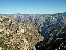
[7] This plateau has an average elevation of 2,250 m (7,380 ft) with most of the more eroded canyons on the western slope, due to the higher moisture content.
The northern end of the range is more arid; hence, the Yaqui River, which drains that area, is an important source of irrigation in the state of Sonora.
[19] The Río Grande de Santiago drains 100,000 km2 (39,000 sq mi) from the southern slopes of the Sierra Madre.
[31] To the south live the indigenous Cora people in the towns of Jesús María and La Mesa del Nayar.
[34] Few paved roads cross the mountains, meaning that travel times can be long, even between cities that are relatively close.
[36] In the mountains, the La Entrada al Pacifico Corridor is an incomplete road intended to connect Los Mochis, Sinaloa and Chihuahua.
The bedrock is covered by the clay rich soils, except in eroded areas, where water carries away deposits leaving a stony surface.
[42] Some of this area has a series of Paleozoic sedimentary sequences from a deep marine environment underlying it, considered by some to be part of the Cotes Terrane and by others to be transported.
[43] Eocene volcanism formed a series of andesitic and rhyolitic formations in the area, with spatial and temporal variations throughout.
The lava has formed a series of mafic rocks that comprise the Southern Cordilleran Basaltic Andesite Suite.
[55] Beginning in the early Miocene and continuing into the middle, an arc of andesite was placed during the spreading of the Gulf of California.
[49] The basin and range-style faulting of the middle-late Miocene took place at the same time as the placement of alkali basalts,[51] In the westernmost slopes mafic dikes formed.
[58] Faults in the area tend to be younger than the upper volcanics, excluding those associated with calderas,[51] but do occur in distinct periods.
[60] The southern boundary of the Sierra Madre Occidental with the Jalisco block is a series of folds, thrust, and left lateral faults date from the middle Miocene.
The Guerrero composite terrane contains many of the economic deposits, often found in ore bodies younger than the Cretaceous.
Air pressure changes in northwestern Mexico and the southwest United States are the main causes of seasonal variation in the Sierra Madre.
[68] The high pressure begins to break down and move south during September or October; however, the breakdown is usually at a slower pace than the movement north.
[73] As the high pressure moves north, air is pulled off the Gulf of Mexico, bringing easterly winds aloft to the mountains.
[74] The mountains cause convection during the following monsoon season,[73] during which nocturnal winds at low levels in the atmosphere move moisture overnight.
[70] Monsoon rains come to the Sierra Madre in June as the high pressure area moves north, leading to wet summer seasons.
In the dry season dew points are low at high elevations (500 hPa), around −22 °C (−8 °F) in the south of the range, and −24 and −26 °C (−11 and −15 °F) in the north in May.
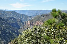
These lower elevations are usually graded into by a stand of tropical deciduous forest, which has a large portion of flora made up of flowering plants and legumes.
[111] A new colonial official, José de Gálvez, came to New Spain and established new laws that caused a boom in silver mining activity in the 1770s.
[119] From there they raided Sonora and the surrounding land until General George Crook entered the mountains in 1883 to discuss Geronimo's return.
[121] Since most of the railroads were American, the foreign influence led to unrest among the people living in the mountains, causing the Tomochic rebellion in 1892.
[121] General John J. Pershing began to follow Pancho Villa in 1916 and entered the mountains; however, he received no information from the local population.