Timeline of the 2011 Pacific hurricane season

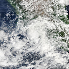
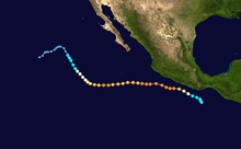
Widespread and destructive flooding and mudslides occurred in southeastern Mexico and Guatemala; at least thirty-six fatalities were directly attributed to the tropical depression itself, with many more in Central America being blamed on the overall weather system.

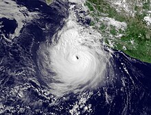
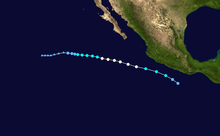
[nb 2] On the same day that Twelve-E made landfall, Hurricane Jova came ashore further to the west, in the Mexican state of Jalisco, at Category 2 strength; high winds and heavy rains killed nine people[7] and caused at least MX$3.164 billion (US$254.3 million) in losses.

[nb 3] Hurricane Beatriz in June claimed four lives when it passed a short distance off the Mexican state of Colima, producing strong winds and locally significant flooding on land.

[10] Hurricanes Adrian in early June, Dora in July, and Hilary in late September all threatened or brushed the Pacific coast of Mexico but only caused minor peripheral effects.

Figures for maximum sustained winds and position estimates are rounded to the nearest five units (knots, miles, or kilometers) and averaged over one minute, following National Hurricane Center practice.

A map of the path of a hurricane off the Pacific coast of Mexico, generally moving to the west-northwest throughout its duration
Track map of Hurricane Adrian
A photograph of a powerful hurricane off the Pacific coast of Mexico
Satellite image of Hurricane Adrian near peak intensity early on June 10
A photograph of a hurricane very close to the Pacific coast of Mexico. Its convection is fragmented and lopsided, hinting that it is about to drastically weaken.
Short-wave infrared satellite image of Hurricane Beatriz making its closest approach to Mexico early on June 21
A map of the path of a hurricane heading west-northwestward away from the Pacific coast of Mexico
Track map of Hurricane Calvin
A map of the path of a hurricane off the Pacific coasts of Central America and Mexico, moving generally northwestward but arcing slightly inward toward the shoreline
Track map of Hurricane Dora
A photograph of a powerful hurricane off the Pacific coast of Mexico. There is slightly less convection and cloud cover in the top-right quadrant of the storm compared to the other three quadrants.
Satellite image of Hurricane Dora at peak intensity on July 21
A map of the path of a hurricane well off the Pacific coast of Mexico, heading generally west-northwestward for its entire life
Track map of Hurricane Eugene
A photograph of a powerful hurricane over the open Pacific Ocean, with long rainbands extending to the south and southwest
Satellite image of Hurricane Eugene at peak intensity late on August 3
A photograph of a tropical storm over the Eastern Pacific Ocean. It has tightly-wound spiral bands, but the convection near the center is broken. A large arc of high clouds is fanning out to the west, north, and northeast of the storm.
Satellite image of Tropical Storm Fernanda late on August 17
A map of the path of a hurricane that moves west-northwestward off the Pacific coast of, and away from, Mexico
Track map of Hurricane Greg
A photograph of a tropical depression over southwestern Mexico
Satellite image of Tropical Depression Eight-E shortly after landfall on August 31
A photograph of a powerful hurricane just off the Pacific coast of Mexico, with some of its northern rainbands spreading over land. The hurricane has an oblong shape, oriented from the lower-left to the upper-right.
Satellite image of Hurricane Hilary at peak intensity late on September 23
A map of the path of a hurricane over the Eastern Pacific Ocean. It begins by moving west-northwestward closely parallel the coast of Mexico; it then shifts westward out to sea, before turning to the northwest later in its life.
Track map of Hurricane Hilary
A photograph of a powerful hurricane off the Pacific coast of Mexico, approaching landfall. A thick rainband curves around the hurricane to its north and is beginning to spread over land, while a long arc of thin, high clouds is fanning out to the southeast, southwest, and northwest.
Satellite image of Hurricane Jova near peak intensity late on October 10
A photograph of a tropical depression over southeastern Mexico and western Guatemala
Satellite image of Tropical Depression Twelve-E just after landfall on October 12
A map of the bumpy but generally westward path of a hurricane off the Pacific coast of Mexico
Track map of Hurricane Kenneth
A photograph of a powerful hurricane over the Eastern Pacific Ocean. It has a clear eye surrounded by a small but nearly axisymmetrical area of deep convection. A large area of high clouds is fanning out to the north and west of the hurricane, with a pronounced band spiraling out to the south and southwest. A small and thin area of convection, oriented north to south, is to the right of Kenneth.
Satellite image of Hurricane Kenneth near peak intensity on November 22