Timeline of the 2011 Atlantic hurricane season

The season officially began on June 1, 2011, and ended on November 30, 2011, dates that conventionally delimit the period of each year when most tropical cyclones develop in the Atlantic basin.

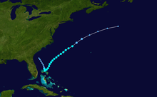
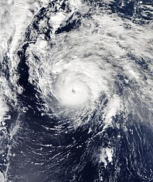
Hurricane Irene was a powerful and unusually large storm that made several landfalls along the East Coast of the United States after peaking with maximum sustained winds of 120 mph (195 km/h).

This timeline documents tropical cyclone formations, strengthening, weakening, landfalls, extratropical transitions, and dissipations during the season.

The time zones utilized (east to west) prior to 2020 were: Atlantic, Eastern, and Central.

Additionally, figures for maximum sustained winds and position estimates are rounded to the nearest 5 units (knots, miles, or kilometers), following the convention used in the National Hurricane Center's products.

A satellite image of a large, swirling mass of clouds making landfall in Mexico
Tropical Storm Arlene after making landfall near Cabo Rojo, Veracruz, as a strong tropical storm
Storm track of a tropical storm that formed east of Florida and moved northeast out to sea
Storm path of Tropical Storm Bret
Satellite imagery of a disorganized tropical cyclone in the Caribbean Sea
Tropical Storm Emily crossing the Windward Islands on August 2
A satellite image of a swirling mass of clouds over the open Atlantic
Tropical Storm Gert spinning over the open Atlantic
A satellite image of the first hurricane of the 2011 Atlantic hurricane season
Irene shortly after being classified as a Category 1 hurricane
Storm track for a short-lived tropical depression in the Eastern Atlantic
Storm track of Tropical Depression Ten
A satellite image depicting a subtropical cyclone prior to making landfall in Louisiana
Satellite imagery of Subtropical Storm Lee shortly before landfall
A satellite image depicting a Category 1 hurricane moving towards Newfoundland
Satellite imagery of Maria as a Category 1 hurricane
A satellite image depicting a well-developed hurricane with a clear eye visible
Hurricane Ophelia at Category 3 strength on October 1
Storm track of a hurricane in the Eastern Atlantic
Storm track of Hurricane Philippe
A satellite image showing Hurricane Rina at peak intensity on October 25
Hurricane Rina at peak intensity
Satellite imagery of Sean as a tropical storm