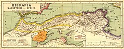
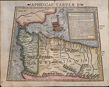
Mauretania Tingitana
[1][2] The territory stretched from the northern peninsula opposite Gibraltar, to Sala Colonia (or Chellah) and Volubilis to the south,[3] and as far east as the Mulucha (or Malva) river.
In the far west, the southern limit of imperial rule was Volubilis, which was ringed with military camps such as Tocolosida slightly to the south east and Ain Chkour to the north-west, and a fossatum or defensive ditch, or commonly known as a trench.
This was not a continuous line of fortifications: there is no evidence of a defensive wall like the one that protected the turbulent frontier in Britain at the other extremity of the Roman Empire.
Indeed, the modern city of Azemmour in central Morocco lies on the ancient Azama, a trading port of Phoenician and later Roman origins.
He has given us the same information as we have received from other sources with reference to the extraordinary height of this mountain, and at the same time he has stated that all the lower parts about the foot of it are covered with dense and lofty forests composed of trees of species hitherto unknown.
The height of these trees, he says, is remarkable; the trunks are without knots, and of a smooth and glossy surface; the foliage is like that of the cypress, and besides sending forth a powerful odour, they are covered with a flossy down, from which, by the aid of art, a fine cloth might easily be manufactured, similar to the textures made from the produce of the silk-worm.
); the road being through deserts covered with a black sand, from which rocks that bore the appearance of having been exposed to the action of fire, projected every here and there; localities rendered quite uninhabitable by the intensity of the heat, as he himself experienced, although it was in the winter season that he visited them.
The Notitia Dignitatum shows also, in its military organisation, a Comes Tingitaniae with a field army composed of two legions, three vexillations, and two auxilia palatina.
However, it is implicit in the source material that there was a single military command for both of the Mauretanian provinces, with a Dux Mauretaniae (a lower rank) controlling seven cohorts and one ala.
All the territory west of Caesarea had already been lost by the Vandals to the Berber "Mauri", but a re-established Dux Mauretaniae kept a military unit at Septem (modern Ceuta).
Stone ruins dating from the Roman era exist at various archaeological sites, including the Capitoline Temple at Volubilis, the palace of Gordius, Sala Colonia, Tingis and Iulia Constantia Zilil.