Tornado outbreak sequence of May 2003
[3][7] On April 30, meteorologists at the Storm Prediction Center (SPC) noted the likelihood of a major tornado outbreak across a large area of the Central and Eastern United States for the period of May 2–6.
[14] Concurrently, decreasing air pressures, steepening lapse rates, and increasing moisture resulted in another conducive area for severe weather over the central Great Plains and along the eastern periphery of the Rocky Mountains.
[26] The day's severe weather was largely driven by a powerful mid-tropospheric disturbance moving northeast across the central and northern Great Plains in tandem with an unusually strong area of low pressure over northeastern Kansas.
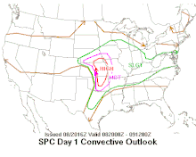
[4] In their Day 2 Convective Outlook, issued on May 3, the SPC indicated that the eastern fringes of the southern Great Plains and the lower and central Mississippi Valley had a moderate risk of experiencing severe weather on May 4.
The SPC cited the confluence of high instability (characterized by convective available potential energy [CAPE] values between 2000 and 4000 J/kg) and strong wind shear as factors contributing to the anticipated tornado outbreak.
[36] The diminishing of the capping inversion along the dry line that had prevented storm development earlier in the day led the SPC to issue a tornado watch at 20:00 UTC (3:00 p.m. CDT) for south-central and southeastern Oklahoma and north-central and northeast Texas.
Tornado watches were issued and remained in effect for various parts of Alabama, Arkansas, Illinois, Indiana, Kentucky, Mississippi, Missouri, North Carolina, Oklahoma, and Tennessee during the early morning hours of May 5 as conditions supported both the persistence of preexisting supercell thunderstorms and the development of new storms.
[49] Despite otherwise supportive conditions for tornadogenesis, rawinsondes launched at 18:00 UTC (1:00 p.m. CDT) suggested that the capping inversion remained in place within the SPC's High Risk region, suppressing the development of storms.
[47] Farther east, a mesoscale convective system formed over Mississippi during the evening within an energetic environment supportive of strong updrafts;[57] however, the cluster of thunderstorms weakened after 03:00 UTC (10:00 p.m. CDT) as air pressures increased, resulting in a diminished threat for severe weather.
[59] At 06:00 UTC (1:00 a.m. CDT) on May 6, the SPC projected a Moderate Risk of severe weather centered on the Ozarks, where dew points above 70 °F (21 °C) and steep lapse rates were expected to foment a highly unstable atmosphere ahead of a rapidly developing low-pressure area and its associated cold front and dry line.
[67][68][69] At around 17:00 UTC (1:00 p.m. EDT), a line of storms exhibiting rotation on weather radar moved into northern Georgia, approaching an area where wind shear favored an isolated tornado threat.
[73] By 20:00 UTC (3:00 p.m. CDT), a supercell was approaching Jefferson City and Columbia in Missouri while cumulus clouds showed signs of further development along a dry line to the south between Tulsa, Oklahoma, and Abilene, Texas.
Several shortwave troughs in the upper levels of the troposphere were expected to track northeastward or eastward across the region, overlapping with a broad and wavy front that extended from New England to New Mexico.
[83] At the time, a large mesoscale convective system, formed from the merger of supercells and other storms, was producing torrential rainfall over Tennessee and Kentucky with rain rates of 2–3 in (51–76 mm) per hour.
[105] Supercells rapidly developed near the warm front by 03:35 UTC (10:35 p.m. CDT) over northern Texas and southern Oklahoma, prompting an issuance of a tornado watch along the Red River; these storms became tornadic and persisted into May 8.
[36] Clearing skies were expected to allow CAPE values to rise unstable levels of around 3000–4000 J/kg, and, when combined with strong southwesterly winds aloft, were forecast to produce an environment conducive to the development of supercell thunderstorms.
[107][108] A more conditional risk for severe weather was predicted along a dry line over the southern Great Plains due to the presence of a capping inversion that was forecast to limit the coverage of storms.
[130] By the evening hours, a broken line of intense supercell thunderstorms were advancing east across eastern Kansas and Oklahoma within a moderately to highly unstable airmass as the pressure of the nearby cyclone deepened to 993 mbar (993 hPa; 29.3 inHg).
[135][136] At 01:00 UTC (8:00 p.m. CDT), the SPC noted that tornadic supercells and conditions conducive to severe weather remained present, though the main risk area shifted east towards the central Mississippi River valley.
[139][140] Widespread thunderstorms—some with mesocyclones—formed over parts of eastern Missouri, Illinois, southwestern Indiana, and western Kentucky during the afternoon in response to the influx of warm and moist air;[141] four tornadoes occurred in these states during the day.
[156] More thunderstorms developed along the dry line by the late afternoon over Texas and Oklahoma with conditions remaining favorable for the formation of supercells,[157] including surface temperatures above 90 °F (32 °C) and dew points above 70 °F (21 °C).
[167] A powerful shortwave trough was forecast to move out of the southwestern U.S. into the southern Great Plains during the day, dragging along a portion of the jet stream with winds exceeding 100 kn (120 mph; 190 km/h).
The approach of this jet stream was expected to increase the divergence of air aloft, leading to the cyclogenesis of a low-pressure area over the central Mississippi Valley that would track northeast towards the Great Lakes.
[179][180] This favorable environment for rising air continued to spread east in tandem with a shortwave trough tracking across the Ohio Valley, extending conducive conditions for thunderstorm development eastward to Virginia and North Carolina in the early afternoon.
[191] Isolated thunderstorms and towering cumulus clouds began to rapidly form along a dry line over central Oklahoma by around noon, with the local atmospheric conditions supportive of strong tornadoes.
[192] Additional supercell thunderstorms quickly emerged over Missouri and eastern Kansas over the next few hours, surrounding by an unstable air mass with CAPE values between 4000 and 5000 J/kg and high wind shear.
[20][201] The lack of storm activity despite otherwise conducive atmospheric conditions may have been caused by subsiding air in the mid-levels of the troposphere over the region as a result of convergent winds aloft, limiting the coverage and depth of thunderstorms.
The tornado continued producing "high end F4" damage to homes as it passed the town of Mulberry, where a train was derailed from the winds of the storm, and crossed into Barton County, Missouri.
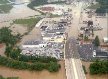
The Tennessee River at Chattanooga reached a stage of 36.1 ft (11.0 m), within a foot of the record high set in February 1973; riverside flooding prompted the evacuation or rescue of hundreds of individuals from adjacent counties and along its tributaries.
[258] In addition to an F0 tornado-producing storm in the Northern Virginia, a second severe thunderstorm producing strong winds caused damage in the Virginian suburbs of Washington, D.C. on May 7, downing power lines and trees in Fairfax County and near Falls Church.