Totmonslow
From the beginning, Staffordshire was divided into the hundreds of Totmonslow, Pirehill, Offlow, Cuttleston and Seisdon.
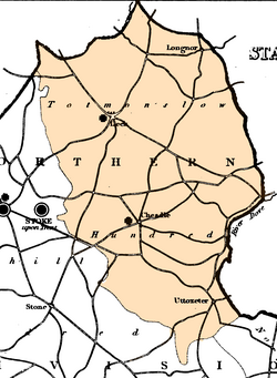
[7] Totmonslow, or Totmanslow, is the north-eastern Hundred of Staffordshire, and contains the upland region called the Staffordshire Moorlands, located at the southern end and foothills of the Pennines, with some of the northern parts falling in the Peak District National Park.
The district contains the valleys of the rivers Dove, Manifold, Hamps, Tean, Blithe, Dane, and Churnet, which have their principal sources in the Hundred, and here receive many small but rapid streams from the high, peaty moorlands and rocky uplands.
In the 19th century it contained four market towns, Leek, Longnor, Cheadle, and Uttoxeter, and about 80 townships located in 10 chapelries and 30 parishes.
[8] After centuries of sheep-grazing the uplands of northern Staffordshire are now to a large extent moorland, although even before this, the region was mostly unattractive to early settlers.