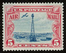
Transcontinental Airway System
The lighted airway was proposed by National Advisory Committee for Aeronautics (NACA), and deployed by the Department of Commerce.
It was situated in the middle of the airmail route to enable aircraft to depart from either coast in the daytime, and reach the lighted airway by nightfall.
[1] By the end of the year, the public anticipated anchored lighted airways across the Atlantic, Pacific, and to China.
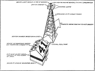
24 inches (610 mm) diameter rotating beacons were mounted on 53-foot (16 m) high towers, and spaced ten miles apart.
The sequence was "WUVHRKDBGM", which prompted the mnemonic "When Undertaking Very Hard Routes Keep Directions By Good Methods".
Many arrow markings were removed during World War II, to prevent aiding enemy bombers in navigation.