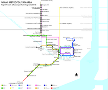
Transit map
Although they prioritize clarity over strict geographic accuracy, the relative positions and connections between stations and routes are still accurately depicted for effective navigation.
Transit map design places a strong emphasis on user needs, ensuring that layouts and visual elements are optimized to empower passengers with intuitive navigation tools, facilitating seamless decision-making and enhancing overall travel experience.
Careful consideration is given to icon choice to distinguish different kinds of stations (regular, interchange or terminal), line styles, colors, typography, and their consistent application for clear, effective and intuitive communication.
After this pioneering work, many transit authorities worldwide imitated the diagrammatic look for their own networks, some while continuing to also publish hybrid versions that were geographically accurate.
The primary purpose of a transit map is to help passengers—especially those unfamiliar with the system—to take the correct routes to travel between two points; this may include having to change vehicle or mode in the course of the trip.
Further help may be granted through the inclusion of important tourist attractions and other locations such as the city center; these may be identified through symbols or wording.
There are a growing number of books, websites and works of art on the subject of urban rail and metro map design and use.
First shown in 1992 and nominated for the Turner Prize, The Great Bear replaces station names on the London Underground map with those of explorers, saints, film stars, philosophers and comedians.