Transportation in North America
There is also an extensive transcontinental freight rail network, but passenger railway ridership is lower than in Europe and Asia.
The railroad network of North America (using standard gauge) is extremely extensive, connecting nearly every major and most minor cities.
The current railheads or endpoints of the rail network are, in the north, at Hay River, Northwest Territories (the northernmost part of the North American rail network, operated by CN), Jackson, British Columbia (formerly BC Rail), Lynn Lake and Churchill, Manitoba (Hudson Bay Railway), Moosonee (Ontario Northland Railway), Chibougamau and Matagami, Quebec (also CN).
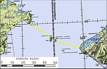
In April 2007 the Russian government announced that it was considering building a rail tunnel under the Bering Strait between Chukotka and Alaska.
The tunnel, as projected, would be 60 miles (100 km) long and would include oil and gas pipelines, fiber optic cables and power lines.
In addition to the Russian government, sponsors of the project apparently include Transneft and RAO United Energy Systems.
Aside from a short spur line linking border city of Ciudad Tecún Umán, Guatemala, the entire nation is on 914 mm (3 ft) gauge.
Like the situation with roads, the Darién Gap is a formidable obstacle to railroads, and no railways cross it into South America.
Many settlements in Alaska are disconnected from the continental road network except by ferry or boat, including the capital Juneau, Sitka, Kodiak, Bethel, Nome, and Utqiaġvik.
[4] The Dalton Highway connects the mainland via Fairbanks with the otherwise remote Prudhoe Bay, Alaska on the North Slope as a service road for the Trans-Alaska Pipeline.
Canada's national highways are similar to the US Route network, as it is mostly two-lane without freeway sections, aside from in and near large population centres, such as Montreal, Calgary, and Edmonton.
In 2004 the provincial government studied the feasibility of a Newfoundland-Labrador fixed link joining the island of Newfoundland to the mainland of North America via a 17 km-long rail tunnel under the Strait of Belle Isle, which would also carry automobile traffic on flat cars, similar to the Channel Tunnel between the United Kingdom and France.
The cities of Duluth, Minnesota, and Thunder Bay, Ontario (to some extent, Chicago, Illinois as well) are the most inland seaports/deepwater ports in the world, being well over 2000 miles from the shores of the Atlantic Ocean, yet they still can cater to cargo ships, thanks to the St. Lawrence Seaway, Welland Canal and Soo Locks, a joint-venture binational system of dams, locks, and canals built by Canada and the United States in 1959.
This canal cuts through the Isthmus of Panama, connecting the Atlantic and Pacific Oceans, shaving off more than 9,000 miles (14,000 km) for ships, instead of having them travel around the tip of Cape Horn in South America.
There is however, rail ferry service between Whittier, Alaska, and Prince Rupert, British Columbia (the AquaTrain, operated by the Alaska Railroad) and Washington state (Seattle), and a ferry to and from Mobile, Alabama, and the Port of Ponce Railroad in Ponce, Puerto Rico.
Regular ferry service also links Vancouver Island and isolated Sunshine Coast communities to the mainland and to Alaska.
Air travel first entered as a viable alternative to transcontinental railroads, and to the then-primitive (or non-existent) road networks that crossed the United States and Canada in the early 1930s, but truly increased in popularity after the Second World War.