Transport in San Marino
Both means are operated by the Azienda Autonoma di Stato per i Servizi Pubblici, the Sammarinese state company for public transport.
[4][5][6] A small general aviation aerodrome in the country's east, Torraccia Airfield, is owned and operated by Aeroclub San Marino,[7][8][9] a flying club with approximately 100 members.
[13][14] The main road is the San Marino Highway, a dual carriageway which runs between Borgo Maggiore and Dogana through Domagnano and Serravalle.
It serves Cerasolo, a frazione of Coriano, and the Rimini Sud exit of the A14 tolled highway, before terminating at the crossroads with the SS16 [it] state road.
[17] Running every fifteen minutes, the two-minute ride is renowned for its paronamic views over San Marino, the Province of Rimini, and the Adriatic Sea.
[22][24] As of December 2023, the Azienda Autonoma di Stato per i Servizi Pubblici, the Sammarinese state company for public transport, operates eight bus routes entirely within San Marino.
[33] In June 2018, the subsequent management company, Airiminum, repainted the terminal sign to read Aeroporto Internazionale di Rimini e San Marino (Rimini and San Marino International Airport), replacing the previous Aeroporto Internazionale Federico Fellini (Federico Fellini International Airport).
It is a small general aviation aerodrome in Torraccia, a village east of the castello of Domagnano, less than 200 metres (660 feet) from the Italian border.
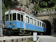
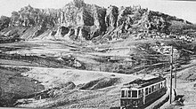
[39][40] Between 1932 and 1944, a 31.5-kilometre (19.6-mile) electrified narrow gauge railway operated between Rimini and the City of San Marino, serving Dogana, Serravalle, Domagnano, and Borgo Maggiore along its route.
[41] During the Second World War, the line was bombed and closed,[41][42] after which its tunnels sheltered refugees during the Battles of Rimini and San Marino.
[11][12] In 2012, an 800-metre (1⁄2-mile) section was reopened as a heritage railway in the City of San Marino, running between Piazzale della Stazione and near Via Napoleone.