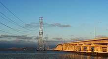
Dumbarton Bridge (California)
Carrying over 70,000 vehicles[1] and about 118 pedestrian and bicycle crossings daily[2] (384 on weekends[3]), it is the shortest bridge across San Francisco Bay at 1.63 miles (8,600 ft; 2,620 m).
The structure was re-striped to accommodate six lanes on October 18, 1989, in response to the temporary closing of the San Francisco–Oakland Bay Bridge due to the Loma Prieta earthquake, and the permanent widening of the approaches was completed by July 2003.
The bridge is part of State Route 84, and is directly connected to Interstate 880 by a freeway segment north of the Fremont end.
Although the present situation has resulted in severe traffic problems on the bridge itself and in Menlo Park and East Palo Alto, Caltrans has been unable to upgrade the relevant portion of Highway 84 to freeway standards for several decades, due to opposition from the cities of Menlo Park, Atherton and Palo Alto.
Freeway opponents fear that upgrading Highway 84 will encourage more people to live in southern Alameda County (where housing is more affordable) and commute to jobs in the mid-Peninsula area (where businesses wish to be located in order to be close to Silicon Valley), thus increasing traffic in their neighborhoods to the south and west of U.S. 101 and even along State Routes 85 and 237.
AC Transit also runs Transbay buses U (Fremont BART and Amtrak to Stanford) and DA (Ardenwood to Oracle and Facebook headquarters) across the bridge.
When the current bridge was planned in the 1970s, Caltrans conducted extensive environmental research on the aquatic and terrestrial environment.
Studies were conducted to produce contour maps of projected sound levels and carbon monoxide concentrations throughout the western approaches, for each alternative connection scheme.
The endangered species California clapper rail is known to be present in the western bridge terminus area.
An accessible portion of the San Francisco Bay National Wildlife Refuge lies immediately north of the western bridge terminus, where the Ravenswood trail runs.
[7] On both sides of the east end of the bridge are large salt ponds and levee trails belonging to the Don Edwards San Francisco Bay National Wildlife Refuge.
[12] A $1 seismic retrofit surcharge was added in 1998 by the state legislature, increasing the toll to $2 (equivalent to $3.74 in 2023), originally for eight years, but since then extended to December 2037 (AB1171, October 2001).
[13] On March 2, 2004, voters approved Regional Measure 2 to fund various transportation improvement projects, raising the toll by another dollar to $3 (equivalent to $4.84 in 2023).
Caltrans administers the "second dollar" seismic surcharge, and receives some of the MTC-administered funds to perform other maintenance work on the bridges.
The Bay Area Toll Authority is made up of appointed officials put in place by various city and county governments, and is not subject to direct voter oversight.
The carpool lane rules will also be standardized across the toll bridges in 2026, with a minimum of three people required to qualify for the discount.
[27] A successful March 2004 regional transportation ballot measure included funding to rehabilitate the rail bridge for the commuter rail service, but in October 2008 the Metropolitan Transportation Commission transferred $91 million from this project to the BART Warm Springs extension in Fremont.


