Tree height measurement
On a slope this base point is considered as halfway between the ground level at the upper and lower sides of the tree.
Other commonly used parameters, outlined in Tree measurement include height, girth, crown spread, and volume.
[4][5] The tallest tree in the world is a coast redwood (Sequoia sempervirens) growing in Northern California that has been named Hyperion.
In the northeastern United States, for example, there are frequent stories published in newspapers and magazines dating from the 1800s telling of extremely tall white pines (Pinus strobus).
[9] One extraordinary account in the Weekly Transcript, North Adams, Mass., Thursday, July 12, 1849 reads: "A Large Tree.
4) If you have an assistant, have them walk away from the base of the tree at a right angle to your position until they reach the spot on the ground that aligns with the top of the stick.
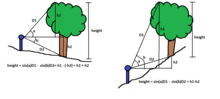
Except for young, plantation-grown conifers, the top of the tree is rarely directly over the base; therefore a right triangle used as the basis for the height calculation isn't truly being formed.
This type of error will be present in all of the readings using the tangent method, except in the cases where the highest point of the tree actually is located directly above the base of the tree, and except in this unusual case, the result is not repeatable as a different height reading would be obtained depending on the direction and position from which the measurement was taken.
Walking around the tree and viewing it from different angles will often help the observer to distinguish the actual top from other branches, but this is not always practical or possible to do.
[2] The development of laser rangefinders was a significant breakthrough in a person's ability to quickly and accurately measure tree heights.
[20] Robert Van Pelt[21] began using a Criterion 400 laser circa 1994 in the Pacific northwest of North America.
He and Will Blozan[22] had previously been using cross-triangulation methods to measure tree heights prior to adopting the laser rangefinder techniques.
Initially, a Bushnell ‘500 Yardage Pro’ laser rangefinder was used in conjunction with a Suunto clinometer to estimate tree heights in all regions.
By checking the characteristics of the laser through a calibration procedure and taking measurements at only the click-over points where the numbers change from one value to the next highest much greater precision can be obtained from the instrument.
The vertical offset from the base of the tree to horizontal can be determined using the tangent method for the lower triangle, where [H2 = tan(A2) x D2].
This ability to scan for the highest point helps eliminate the second major source of error caused by misidentifying a forward leaning branch or the wrong top.
[28][29] He writes: "When heights were measured properly and under favorable circumstances, the results obtained by the tangent and sine methods differed only by about 2 percent.
These examples also highlight a number of distinct advantages of using the sine method, especially when exact tree height is required.
Standard ten foot sections of PVC pipe can be used for the poles, but they tend to become floppier with increasing length."
Once safely anchored from that position the climber finds a clear path and drops a weighted line to the ground.
Fiberglass tapes are generally used for these measurements because of their light weight, negligible stretch, and because they do not need to be calibrated for use at different temperatures.
The climber pulls up an extendable pole and uses it to reach to the top of the tree from the point at the upper end of the tape.
A theodolite with an electronic distance measurement (EDM0 function or Total Station can provide accurate heights because a specific point on the tree crown could be consistently chosen and "shot" through a high magnification lens with cross hairs mounted on a tripod which further steadied the device The drawbacks are the prohibitive cost of the instrument for average users and the need for a well cut corridor for horizontal distance measurement has to be cleared for every measurement, and the general lack of easy portability.
[39] It is possible to measure the height of a tree indirectly without taking any horizontal sweep angles, which can be difficult to obtain accurately in the field.
LiDAR, an acronym for Light Detection and Ranging, is an optical remote sensing technology that can measure distance to objects.
Tree heights acquired using conventional field techniques (-0.27 2 0.27 m) were more accurate than those obtained using LiDAR (-0.73 i: 0.43 m for narrow beam setting).
Maps of global canopy heights have been developed using LiDAR by Michael Lefsky in 2010[45] and updated a year later by a team led by Marc Simard of NASA's Jet Propulsion Laboratory.
They have found LiDAR to be a useful tool for scouting locations prior to visits, but the values need to be ground truthed for accuracy.
Michael Taylor writes: "In the flat areas like Humboldt Redwoods State Park the LiDAR was usually within 3 feet (91 cm) accuracy and tended to be on the conservative side.
In 2012 Google Earth began offering 3D models of some major cities using stereophotogrammetry[53] which allows users to measure the height of buildings and trees by adjusting the altitude of a Polygon in 3D, or use the Ruler function to measure the height of an object in a 3D path in Google Earth Pro.