Tree measurement
Specimens may grow as individual trunks, multitrunk masses, coppices, clonal colonies, or even more exotic tree complexes.
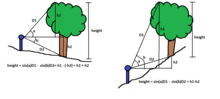
Historically the most direct method of finding a tree's height was to cut it down and measure it prostrate on the ground.
With calibration, multiple shots, and a technique to deal with scales that read only to the nearest yard or meter, tree heights can typically be measured to within one foot using this methodology.
[21] Tree girth measurement is commonly performed by wrapping a tape around the trunk at the correct height.
Tree girth may also be measured remotely using a monocular with reticle, through photographic interpretation, or by some electronic surveying instruments.
[2][8] In these remote methods a diameter perpendicular to the surveyor is what is actually being measured and that is converted to girth by multiplying that number by pi.
For trees in open areas, crown spreads can also be measured from aerial imagery such as Google Earth.
The upper end of the tape is lightly tacked at this point and allowed to hang freely down the trunk.
Many trees flare outward significantly at the base and this basal wedge has a complex surface of bumps and hollows.
In footprint mapping a level, rectangular reference frame is placed around the base of the tree to create a horizontal plane.
Taylor[29][30] has been developing a cloud mapping process using optical parallax scanning technology whereby thousands of measurements are made around the trunk of a tree.
These trees should be documented even if the results are in the form of a written narrative rather than a collection of numerical measurements.
This occurs frequently in some species when the initial trunk has been damaged or broken and in its place two or more new shoots grow from the original root mass.
Ternary plots can be used to graphically display any set of data that includes three terms which total to some constant.
[38] The average girth, height, and crown spread values were calculated for the measurements included in the listing.
The cluster representing the live oak data falls on the extreme edge of the general pattern of tree shapes.
The Data Bank includes raw ring width or wood density measurements, and site chronologies.
[citation needed] The oldest known tree is a Great Basin bristlecone pine, Pinus longaeva, growing in the White Mountains of eastern California.
[42] Older ages are given for sprouts growing from roots or clonal colonies, but these values are not from an individual stem that has persisted for that duration.
[citation needed] In spite of the extensive amounts of work done by dendrochronologists in investigating trees, the maximum ages attainable by most common species is not clear.
American Forests describe it as a conservation movement to locate, appreciate and protect the biggest tree species in the United States with more than 780 champions crowned each year, with 200 more species without a crowned champion in 2012, and documented in their biannual publication — the National Register of Big Trees.
[citation needed] For example, the Australian National Register of Big Trees[46] uses the American Forests formula.
A tree scaling close to 300 would suggest that it was nearly the largest specimen theoretically possible based on currently known maxima.
A two-value TDI using height and girth was presented for 259 white pines (Pinus strobus) by Friends of Mohawk Trail State Forest to MA DCNR in 2006.
[citation needed] Studies have shown that trees contribute as much as 27% of the appraised land value in certain markets and cite the following table[49] which can be extrapolated with care.
A general model for any year and diameter is The right side of this equation is written to paste into Excel or Google to perform the calculation.
The actual accuracy users attain depends on a number of factors, including atmospheric effects and receiver quality.
Real-world data collected by the FAA show that some high-quality GPS SPS receivers currently provide better than 3 meter horizontal accuracy.
High index values are the result of many factors, including climate, topography, soils, and a lack of disturbance.
The Rucker Height Index is essentially a foreshortened version of a complete profile of all the species found on a particular site.