Tree volume measurement
Ground-based methods use optical and electronic surveying equipment to remotely measure the end diameters and the length of each section.
[citation needed] The largest trees in the world by volume are all Giant Sequoias in Kings Canyon National Park.
A measuring (reference) tape is then attached via a small carabineer to the dropped throw line and pulled up to the top, following the vertical path of the weight's descent.
[citation needed] The climber pulls up an extendable pole and uses it to reach to the top of the tree from the point at the upper end of the tape.
Bifurcations often form an irregularly shaped fused section that cannot be accurately measured with a tape for the purpose of computing cross-sectional area.
[1][2] As part of the Tsuga Search Project, a frame mapping technique was developed to allow characterization of significantly large fusion areas at forks in the trees.
Two poles, longer than the diameter of the fused section, are lifted in place and connected by a thin rope threaded through opposite ends so they are adjustable.
[citation needed] Many trees flare outward significantly at the base and this basal wedge has a complex surface of bumps and hollows.
In footprint mapping a level, rectangular reference frame is placed around the base of the tree, to create a horizontal plane.
[citation needed] A combination of a monocular w/reticle, laser rangefinder, and a clinometer [1][2] can be used to do go from simple diameters to a full measure of trunk volume.
With the distance known, the diameter of the tree measured expressed as units of the reticle scale, and an optical scaling factor for the monocular w/reticle, provided by the diameter of the tree at that point can be calculated: To assure accuracy, the calibration of the optical factor should be checked for each instrument rather than solely relying upon the manufacturer's specifications.
Diameters can sometimes be measured with the monocular w/reticle in sections where it is difficult to obtain accurate laser distances because intervening thin brush or branches.
[citation needed] Point cloud mapping is a process being developed by Michael Taylor [9][10][11] using optical parallax scanning technology whereby thousands of measurements are made around the trunk of a tree.
There are a handful of widely available technologies including ground LIDAR) and optical parallax scanners that can quickly and accurately map a trunk.
The problem is in a cluttered forest environment you get a lot of 'noise' and unwanted cloud points, hundreds of thousands potentially, but these can be filtered out.
The data can be saved as a .ply file which can be viewed and manipulated with a variety of software packages including the free open source 3D graphics viewer Meshlab.
[13] There are several software programs available that can be used to calculate the volume of the space defined by the point cloud including some tree specific currently under development.
[citation needed] Detailed three dimensional mapping of the trunk and major branches of trees can be done for significant specimens.
The methodology used to map the Middleton Oak and the Sag Branch Tuliptree was developed by Dr. Robert Van Pelt.
[citation needed] Van Pelt et al. (2004) outlined the process in Quantifying and Visualizing Canopy Structure in Tall Forests: Methods and a Case Study.
These lengths are considered to be the top and base of a regular trapezoid with a height equal to the difference in the distance between the two points.
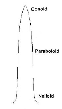
[citation needed] The best method for modeling that is to divide the trunk into adjacent segments no more than 3 to 5 feet in height/length and then apply either the cone, paraboloid, or neiloid frustum form to each.
Therefore, when modeling longer frustums the measurer needs to perform independent checks to insure that the right solid has been chosen.
Each frustum can represent a different parent cone, paraboloid, or neiloid so that there is not a need to impose a single form on the entire tree.
The neiloid form often applies near the base of tree trunks exhibiting root flare, and just below limb bulges.
[citation needed] Some of the older Mohawk Trail State Forest pines in western Massachusetts are growing at a rate of slightly less than double the rate of the young pines in terms of absolute volume increases with an average annual volume increase of 11.9 ft3 over the referenced time periods.
The Ice Glen pine, in Stockbridge, Massachusetts, estimated to be around 300 years old or possibly older based on dating of nearby pines, shows a decline in annual volume increase to approximately half of that for the trees in the 90 to 180-year age class, but still averaged a volume increase of 5.8 ft3 over the five year monitoring period.
For young to mature Eastern White Pines, applying the cross-sectional area at trunk flare with full tree height in the cone formula almost always overstates the fully modeled volume.
It is suggested that these flare and taper could be extended in some cases to values in the range of 0.80 and 1.25 to allow extreme forms to be characterized by the formula.
Similarly a model of overall trunk volume could potentially be predicted by using height, girth above basal flare, and the percent cylinder occupation for that species and age class.