Trnava (Želivka)
The name is derived from the Czech word trn ('thorn'), meaning "the river flowing through thorns (thorly bushes)".
[1] The Trnava originates in the territory of Vodice in the Křemešník Highlands at an elevation of 672 m (2,205 ft) and flows to Želiv, where it enters the Želivka River at an elevation of 393 m (1,289 ft).
[2] The longest tributaries of the Trnava are:[3] The river flows through the municipal territories of Vodice, Dolní Hořice, Cetoraz, Pacov, Zhořec, Těchobuz, Salačova Lhota, Bratřice, Velká Chyška, Samšín, Lesná, Hořepník, Bořetice, Rovná, Arneštovice, Křelovice, Červená Řečice and Želiv.
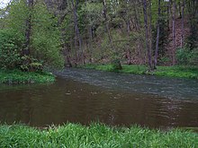
In almost its entire length, the Trnava passes through a 100–200 m wide valley with steep, mostly wooded slopes.
Since 2014, there has been an annual event known as the Trnava X-race, which is an extreme kayak and canoe race.