National Hurricane Center
The National Hurricane Center (NHC) is the division of the United States' NOAA/National Weather Service responsible for tracking and predicting tropical weather systems between the Prime Meridian and the 140th meridian west poleward to the 30th parallel north in the northeast Pacific Ocean and the 31st parallel north in the northern Atlantic Ocean.
The Chief, Aerial Reconnaissance Coordination, All Hurricanes (CARCAH) unit tasks planes, for research and operational purposes, to tropical cyclones during the Atlantic hurricane season and significant weather events, including snow storms, during winter and spring.
When tropical storm or hurricane conditions are expected within 48 hours, the center issues watches and warnings via the news media and National Oceanic and Atmospheric Administration (NOAA) Weather Radio.
[10] The Miami Hurricane Warning Office (HWO) moved from Lindsey Hopkins Hotel to the Aviation Building 4 miles (6.4 km) to the northwest on July 1, 1958.
[30] In 1978, the NHC's offices moved off the campus of the University of Miami across U.S. Highway 1 to the IRE Financial Building.
[36] The radar was replaced with a WSR-88D NEXRAD system in April 1993 installed near Metro Zoo,[37] near where Hurricane Andrew made landfall.
In 1995, the NHC moved into a new hurricane-resistant facility on the campus of Florida International University, capable of withstanding 130 mph (210 km/h) winds.
[42][43] The World Meteorological Organization continues to create and maintain the annual hurricane naming lists.
The specialists work rotating eight-hour shifts from May through November, monitoring weather patterns in the Atlantic and Eastern Pacific oceans.
If systems occur outside the defined hurricane season, the HSU issues special Tropical Weather Outlooks.
[53] On January 3, 2022, it was announced that senior hurricane specialist Stacy Stewart, who also served in the U.S. Navy reserves, retired after working at the NHC since 1999.
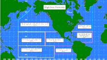
[55] The TAFB is responsible for high seas analyses and forecasts for tropical portions of the Atlantic and Pacific between the Prime Meridian and the 140th meridian west poleward to the 30th parallel north in the northeast Pacific Ocean and the 31st parallel north in the northern Atlantic Ocean.
[57] The Ocean Prediction Center backs up TAFB in the event of a communications outage, and vice versa.
[58] The Technology & Science Branch (TSB) develops and transitions new tools and techniques into operations for tropical weather prediction in conjunction with other government and academic entities.
TSB maintains a number of statistical and dynamical models used in predicting both tropical cyclone behavior and associated weather conditions.
CARCAH's mission is to provide a point-of-contact and to coordinate all tropical cyclone operational reconnaissance requirements at NHC and the Central Pacific Hurricane Center for the North Atlantic, Caribbean, Gulf of Mexico, and the North Pacific basin east of the International Date Line in accordance with the National Hurricane Operations Plan (NHOP).
The report summarizes the synoptic history, meteorological statistics, casualties and damages, and the post-analysis best track of a storm.