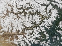
Yarlung Tsangpo Grand Canyon
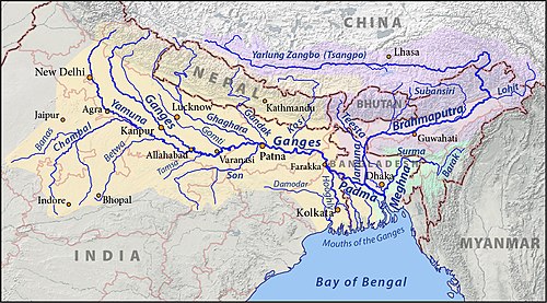
[1][3] The Yarlung Tsangpo (Tibetan name for the upper course of the Brahmaputra) originates near Mount Kailash and runs east for about 1,700 kilometres (1,100 mi), draining a northern section of the Himalayas before it enters the gorge just downstream of Pei, Tibet, near the settlement of Zhibe.
The canyon has a length of about 240 kilometres (150 mi) as the gorge bends around Mount Namcha Barwa (7,782 metres or 25,531 feet) and cuts its way through the eastern Himalayas.
The canyon is home of a South Tibetan cypress (Cupressus austrotibetica) that is 102.3 metres (336 ft) tall and, upon its discovery in 2023, is believed to be the tallest tree in Asia.
[9] In 1913, Frederick Marshman Bailey and Henry Morshead launched an expedition into the gorge that finally confirmed that the Tsangpo was indeed the upper Brahmaputra.
Frank Kingdon-Ward started an expedition in 1924 in hopes of finding a major waterfall explaining the difference in altitude between the Tsangpo and the Brahmaputra.
[11] In January–February 2002 an international group with Scott Lindgren, Steve Fisher, Mike Abbott, Allan Ellard, Dustin Knapp, and Johnnie and Willie Kern completed the first full descent of the upper Tsangpo gorge section.
[12][13] The largest waterfalls of the gorge (near Tsangpo Badong, Chinese: 藏布巴东瀑布群[14]) were visited in 1998, by a team consisting of Ken Storm, Hamid Sarder, Ian Baker and their Monpa guides.
The falls and rest of the Pemako area are sacred to Tibetan Buddhists who had concealed them from outsiders including the Chinese authorities.
[6][17] While the government of the PRC has declared the establishment of a "Yarlung Tsangpo Grand Canyon National Reservation", there have also been governmental plans and feasibility studies for a major dam to harness hydroelectric power and divert water to other areas in China.
[21] Steel dams are more advantageous and economical in remote hilly terrain at high altitude for diverting the run off water of the river to power generating units.