Department of Tumbes
Morphologically, four zones can be defined in the region: the delta of the Tumbes and Zarumilla rivers; an alluvial plain north of the Tumbes River, with dry, low-depth ravines; ancient terraces that have been strongly eroded in the Máncora area; and the Amotape mountain range in the east and south, ending at El Barco Mountain.
Basically composed of a large mestizo population rooted in a mixture between the pre-Incan Tumpis and Tallanes tribes, Spanish, creoles, the African peoples, including mulatos or zambos, and a small Chinese community of mostly Cantonese ancestry.
[citation needed] The fact that Tumbes lies so close to the Equator has determined its landscape, which teems in plant life.
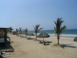
Its pure white sands, sun and warm weather all year long, and a sea ideal for water sports, make the beach of Punta Sal one of the finest on the Peruvian coast.
The mangroves have formed vast clumps of saltwater-tolerant coastal forests which have created a unique ecosystem linking the river and the sea.
Not far from Zorritos lies the Bocapán beach, where visitors can swim in Hervideros, natural hot springs bubbling with iodized salts.
The typical dishes of the Tumbesino cuisine are based on seafood— ceviche of black scallops, crab, or shrimps, or cebiche mixto— and Tumbiresas covered by yucca and banana balls broth with dominicos, meat, red peppers, eggs, olives, raisins, flour, coriander and other herbs.
A typical beverage in the region is the chinguirito, which is obtained by combining pipa (the milk of a soft coconut) with the famous grape brandy called pisco.