Tunis
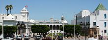
East of the Medina, through the Sea Gate (also known as the Bab el Bhar and the Porte de France), begins the modern part of the city called "Ville Nouvelle", traversed by the grand Avenue Habib Bourguiba (often referred to by media and travel guides as "the Tunisian Champs-Élysées"), where the colonial-era buildings provide a clear contrast to smaller, older structures.
[2][3] Some scholars claim that it originated from Tynes, which was mentioned by Diodorus Siculus and Polybius in the course of descriptions of a location resembling present-day Al-Kasbah, Tunis's old Berber village.
There are also some mentions in ancient Roman sources of such names of nearby towns as Tuniza (now El Kala), Thunusuda (now Sidi-Meskin), Thinissut (now Bir Bouregba), and Thunisa (now Ras Jebel).
Early on, Tunis played a military role; the Umayyads recognized the strategic importance of its proximity to the Strait of Sicily, with a dockyard built upon the founding of the city by order of Caliph Abd al-Malik.
From the beginning of the 8th century, Tunis was the chef-lieu of the area: it became the Umayyad, and later the Abbasids' naval base in the western Mediterranean Sea, and took on considerable military importance.
Exposed to violence from the hostile tribes that settled around the city, the population of Tunis repudiated the authority of the Zirids and swore allegiance to the Hammadid prince El Nacer ibn Alennas, who was based in Béjaïa, in 1059.
At the same time, driven by the reconquest of Spain, the first Andalusian Muslims and Jews arrived in Tunis and would become of importance to the economic prosperity of the Hafsid capital and the development of its intellectual life.
[21] The Ottoman Empire took nominal control of Tunis in 1534 when Hayreddin Barbarossa captured it from the Hafsid Sultan Mulai Hassan, who fled to the court of Charles V, Holy Roman Emperor and King of Spain.
Charles, suffering losses from the corsairs operating out of Djerba, Tunis, and Algiers, agreed to reinstate Mulai Hassan in exchange for his acceptance of Spanish suzerainty.
The Spanish governor of La Goulette, Luys Peres Varga, fortified the island of Chikly in the lake of Tunis to strengthen the city's defenses between 1546 and 1550.
[30] Having succeeded in driving the Axis powers out of Tunisia, the Allies used Tunis as a base of operations from which to stage amphibious assaults first against the island of Pantelleria, and then Sicily, and finally the mainland of Italy.
On the expenditure side, provision is made for the consolidation of hygiene and cleanliness, the state of the environment and urban design, infrastructure maintenance, rehabilitation and renovation of facilities, and strengthening the logistics and means of work and transport.
[55] As in the rest of Tunisia, literacy in the region of Tunis evolved rapidly during the second half of the 20th century and has reached a level slightly higher than the national average.
[56] Gulf finance house or GFH has invested $10 billion [citation needed] in order for the construction of Tunis financial harbor, which will transform Tunisia as the gateway to Africa from Europe.
The axis to the structure of this part of the city is the Avenue Habib Bourguiba, designed by the French to be a Tunisian form of Champs-Élysées in Paris with its cafes, major hotels, shops, and cultural venues.
South-east of the Avenue Bourguiba the district of La Petite Sicile (Little Sicily) is adjacent to the old port area and takes its name from its original population of workers from Italy.
North of the Avenue Bourguiba is the district of La Fayette, which is still home to the Great Synagogue of Tunis and the Habib Thameur Gardens, built on the site of an ancient Jewish cemetery that lay outside the walls.
Also to the north is the long Avenue Mohamed V, which leads to the Boulevard of 7 November through the neighborhood of the big banks where there are hotels and Abu Nawas Lake and finally to the Belvedere area around the place Pasteur.
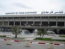
Beyond that, several kilometers north-east, on the road to La Marsa, the Berges du Lac was built on land reclaimed from the north shore of the lake near the airport, which has held offices of Tunisian and foreign companies, many embassies as well as shops.
Northwest of the latter, north of the National Route 3 leading to the west, is the city of Ezzouhour (formerly El Kharrouba), which spans more than three metres (9.8 feet) and is divided into five sections.
However, studies were undertaken in the 1930s with the arrival of the first anthropologists who found that the space of the Medina is not random: the houses are based on a socio-cultural code according to the types of complex human relations.
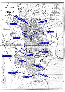
Domestic architecture (palaces and townhouses), official and civilian (libraries and administrations), religious (mosques and zaouïas), and services (commercial and fondouks) are located in the Medina.
The Medina also has a social sectorization: with the neighborhood of Tourbet el Bey and the Kasbah district being aristocratic, with a population of judges and politicians, while the streets of Pacha often being military and bourgeois.
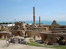
The area became the capital of a powerful kingdom during the Hafsid era and was considered a religious and intellectual home and economic center for the Middle East, Africa, and Europe.
The main conflicts and potentially destructive human behavior has been experienced in the city occurred relatively recently following the country's independence which is why it made into a World Heritage Site by UNESCO in 1979.
The Arab geographer El Yacoubi has written that in the 9th century Tunis was surrounded by a wall of brick and clay except for the side of the sea where it was stone.
[76] The National Military Museum, opened in 1989 in the suburbs west of the city, holds a collection of 23,000 weapons, 13,000 of which date back to the 19th century, and some of which were used by the Tunisian troops during the Crimean War.
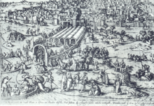
was published in Fisher's Drawing Room Scrap Book, 1838 with a poetical illustration by Letitia Elizabeth Landon that comments on the potential the city has for development.
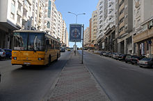
[91] The growing metropolitan area is served by an extensive network of public transportation including buses, an above-ground light rail system (le Metro), as well a regional train line (the TGM) that links the city center to its closest northern suburbs.
Between 1928 and 1955 the city hosted nine rounds of the Grand Prix of Tunis, where notable drivers such as Marcel Lehoux, Achille Varzi, Tazio Nuvolari and Rudolf Caracciola took part.