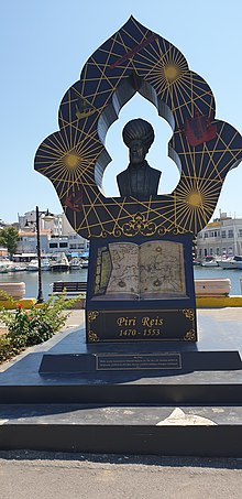
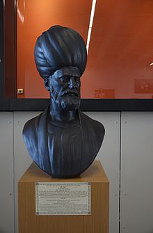
Piri Reis
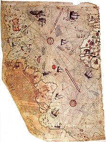
His final surviving work is a 1528 world map, of which only the northwest corner remains (showing Greenland, Labrador, Newfoundland, Florida, Cuba, Hispaniola, Jamaica, and Central America).
[13] To bolster the empire's navy, Ottoman Sultan Bayezid II recruited Barbary and Aegean corsairs, including Piri and Kemal.
[16] In the empire's navy, Kemal and Piri advocated taking the Venetian coastal fortresses of the Peloponnese and the small but strategically valuable island of Rhodes.
[27] The finished manuscript of his first world map was dated to the month of Muharram in the Islamic year 919 AH, equivalent to March 1513 AD.
[30] Although he had never sailed the Atlantic, he compiled over twenty maps of Arab, Spanish, Portuguese, Indian and older Greek origins into a comprehensive representation of the known world of his era.
[44][45] The second version of the Kitab-ı Bahriye, completed after the conquest of Rhodes, only discusses the events in terms of the practical concerns of acquiring drinking water from Karabağ in Bodrum prior to the siege.
[48] When putting down Hain Ahmed Pasha's 1524 rebellion in Egypt, Ibrahim rode aboard the navy's flagship, commanded by Piri Reis.
[54] In both the 1513 world map and the Kitab-ı Bahriye preface, Piri Reis rhetorically undermines the significance of European discoveries by reframing them as the rediscovery of ancient knowledge.
[57] Marginal inscriptions on the world map mention "charts drawn in the days of Alexander" and a book that "fell into the hands" of Columbus describing lands "at the end of the Western Sea".
[58][59] In the 1526 version of the Kitab-ı Bahriye, he explicitly credits European discoveries to lost works created during legendary voyages of Alexander, "My friend, the Franks both read and write everything there is to know about the science of the sea.
[64] Using his fleet based out of Suez, Egypt, Piri Reis led campaigns in the Red Sea and Persian Gulf.
[63] Piri Reis subdued the local Bedouin rulers of Basra in 1547 and began building a Persian Gulf fleet.
[65] The fleet conducted annual expansions in the Indian Ocean, and some local rulers began to ally with the Portuguese.
[72] They besieged and bombarded the fortress for several weeks, but Piri Reis grew concerned about the Portuguese fleet attacking them during the siege.
[73] The Ottoman forces ran low on gunpowder, and Kubad Pasha the governor of Basra did not send supplies to the siege.
[76] A letter from the Portuguese governor inside the fortress, dated 31 October 1552, said that the walls had been near collapsing, but that the Ottomans had run low on "munitions, gunpowder, and other war materials" much of which they had lost when a galleon sank on the way to Hormuz.
[82][83] Copies of the Kitab-ı Bahriye, a navigational atlas, are kept in many libraries and museums around the world, although the two created by Piri Reis himself are lost.
[36] When rediscovered in 1929,[90] the remaining fragment garnered international attention for including a partial copy of an otherwise lost map by Christopher Columbus.
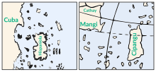
Scholars attribute the peculiar arrangement of the Caribbean to a now-lost map from Columbus that merged Cuba into the Asian mainland and Hispaniola with Marco Polo's description of Japan.
[110] Piri Reis adapted the elements of iconography from the traditional maps—which illustrated well-known routes, cities, and peoples—to the portolan portrayals of newly discovered coasts.
[114] Some authors have noted visual similarities to parts of the Americas not officially discovered by 1513,[115] but there is no textual or historical evidence that the map represents land south of present-day Cananéia.
[51] It offers the first detailed Ottoman description of the Indian Ocean,[127] and gives special attention to Hormuz Island at the strait leading into the Persian Gulf.
[132] The map does include one line of latitude, the Tropic of Cancer; it is slightly south of the correct position for Cuba and the Yucatan.
Historian Svat Soucek said of the cartographic works of Piri Reis, "They show that although the Ottoman Empire had the potential to participate in the discoveries, its ruling elite spurned the attempt to blaze a trail in this direction".
[143] The empire's navy—even during the Canary Islands expedition—remained largely composed of oar-driven galleys after the point where other naval powers were moving to sailing ships that were more suited to the open oceans.
[143] Ottoman scholar Kâtip Çelebi built on the Kitab-i Bahriye in his seventeenth-century work, Müntehab-ı Bahriyye.
[91] Turkey's first president, Mustafa Kemal Atatürk, took an interest in the map and initiated projects to publish facsimiles and conduct research.
[154] Piri Reis' 1513 world map is the target of various pseudoscientific claims and is sometimes invoked in broader pop culture as an unsolved mystery.
[156] According to geologist Paul Heinrich, the book also did not account for post-glacial rebound, and the 1949 survey initially cited by Mallery could not measure even one percent of the area drawn in the Piri Reis map.
[158][159] The map and polar shift were key plot elements in Allan W. Eckert's science fiction novel The HAB Theory.