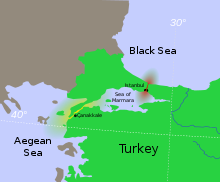
Turkish straits

Owing to their strategic importance in international commerce, politics, and warfare, the Straits have played a significant role in European and world history.

The Turkish Straits are made up of the following waterways; Developments of economic activities threaten marine ecosystems including endemic dolphins and harbour porpoises.

[2] The Straits have had major maritime strategic importance since at least the Mycenaean period, and the narrow crossings between Asia and Europe have provided migration and invasion routes (for Persians, Galatians, and Turks, for example) for even longer.

By the terms of the London Straits Convention concluded on 13 July 1841 between the Great Powers of Europe — Russia, the United Kingdom, France, Austria and Prussia — the "ancient rule" of the Ottoman Empire was re-established by closing the Turkish straits to all warships whatsoever, barring those of the Ottoman Sultan's allies during wartime.

Anglo-French naval forces failed to take control of the Dardanelles (February – March 1915), but in the secret Straits Agreement diplomacy of March – April 1915, the members of the Triple Entente agreed — in the event of victory in World War I — to cede Ottoman territory controlling and overlooking the Straits to the Russian Empire.

The Bosphorus (red), the Dardanelles (yellow), and the Sea of Marmara in between, are known collectively as the Turkish straits
Satellite image of the Bosphorus , taken from the International Space Station in April 2004. The body of water at the top is the Black Sea , the one at the bottom is the Sea of Marmara , and the Bosphorus is the winding vertical waterway that connects the two. The western banks of the Bosphorus constitute the geographic starting point of the European continent, while the banks to the east are the geographic beginnings of the continent of Asia . The city of Istanbul is visible along both banks.
View of the Dardanelles , taken from the Landsat 7 satellite in September 2006. The body of water at the upper left is the Aegean Sea , while the one on the upper right is the Sea of Marmara . The long, narrow upper peninsula is Gallipoli ( Turkish : Gelibolu ), and constitutes the banks of the continent of Europe, while the lower peninsula is Troad ( Turkish : Biga ) and constitutes the banks of the continent of Asia . The Dardanelles is the tapered waterway running diagonally between the two peninsulas, from the northeast to the southwest. The city of Çanakkale is visible along the shores of the lower peninsula, centered at the only point where a sharp outcropping juts into the otherwise-linear Dardanelles.