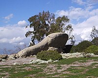
Turtle Rock, Irvine, California
[2] A two-lane internal loop road, Turtle Rock Drive, encircles the village and carries traffic between housing developments and the city's main streets.
In 2021, the City Of Irvine conducted surveys and consulted with indigenous leaders, before officially naming the hill "Sunset Point".
[4] While it is not entirely clear where the name "Turtle Rock" comes from,[5] there is a rocky outcropping on Rockview Drive at the northern end of the neighborhood (33°39′15″N 117°49′01″W / 33.65417°N 117.81694°W / 33.65417; -117.81694) that is now maintained as part of an association park.
Planning and housing issues within Turtle Rock have been discussed regularly in Southern California newspapers.
[9] Henry Irving[10] uses Turtle Rock as one of several test cases for analysis of urban communication.

