Twin Lakes Beach, Manitoba
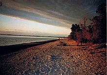
Plants can strive on the natural dune because after a storm occurs on the lake, the water levels increase, washing dead seaweed and other organic matter, onto the sand.
The water, however, continuously laps the shore, due to moving air and currents, leaving a section of the dune eroded where sand remains, forming a beach.
Lake Manitoba boasts a high number of cottage dwellings and sandy beaches, mainly occupied in the summer months.
The area around Twin Lakes Beach and St. Laurent is composed of reasonably-fertile land, which is suitable for crops.
The earliest records of civilization (of course long after Aboriginal peoples inhabited Manitoba, prior to dated history) around the Twin Lakes Beach and St. Laurent area began in the early 19th century, when the McKay family, of Metis descent, were one of the first families to settle in St. Laurent, on the shores of Lake Manitoba.
[3] It was after this time that the land was subdivided and many people began to purchase lakefront properties in the area initially mainly for summer homes and cottages, but also for permanent residences later on.
The desire to purchase a beachfront property has drastically increased even in the past decade, spiking the interests of many Manitoban citizens, and attracting them to the province's beautiful beaches and lakes.
The beach is located approximately one hour north of Winnipeg on Provincial Hwy 6, just a few kilometers off the highway.
While this may benefit some industries and cottagers, in places like Twin Lakes Beach it does not allow the sand to build up dunes around vegetation as it would in a drought.
[10] This was passed in terms of volume of water in 2011 as the Portage Diversion took on up to 34,804 cu ft/s (985.5 m3/s) in a desperate attempt to prevent major flooding downstream.
Also in 2011, the duration of use of the Portage Diversion was longer than ever before in as it was in operation from April 6 to August 5 running for a total of 122 days due to continued precipitation in the spring and into the summer.
[11][12][13] After closing on August 5, just under 4,700,000 acre-feet (5.8 km3) (4.1 feet (1.2 m) rise) of water was directed toward Lake Manitoba rather than Winnipeg and the Red River, this number being more than three times the volume of the 1976 flood.
[5][13][14][15] Twin Lakes Beach has been the recipient of many storms causing shoreline erosion, flooding and property damage.
The 1999 storm caused an estimated $1 million in damage and was a catalyst for establishing new regulation of lake levels.
On July 29, 2012 a thunderstorm occurred at Twin Lakes Beach causing widespread damage to property including complete destruction of homes due to heavy rain, hail, and plow winds with gusts up to 150 km/h recorded on radar.
[16][17] Twin Lakes Beach experiences a humid continental climate (Köppen Dfb[18]) with warm to hot summers and cold windy winters.
In the spring, when the ice has not yet melted, any wind off the lake can also depress temperatures compared to nearby locations.
In the fall and early winter before freeze-up Twin Lakes Beach also experiences periodic lake-effect snow.
Wind coming off the lake also tends to be stronger than nearby locations due to less resistance, and this can lead to extreme windchills and snow drifts in the winter.
However, the forecast was revised upwards numerous times due to precipitation and the extended use of the Portage Diversion to an eventual predicted peak as high as 817.81 feet (249.27 m) above sea level, well above the regulated range as well as the flood stage of 814 feet (248 m) above sea level, at the end of July.
Mandatory evacuations were ordered by the Rural Municipalities of Woodlands and St. Laurent to all cottagers and permanent residents on Twin Lakes Beach.
[35][36] Beginning in early September with construction running into October, TITANTubes (sometimes referred to as geotubes or geotextile tubes) manufactured by Flint Industries(USA) were installed along most of the shoreline of the section of the beach in the Rural Municipality of Woodlands.
[39] Also in the fall, demolition crews were brought in to demolish those residences in Woodlands that were classified as Level 4 as a result of the May 31 and subsequent storms.