U.S. Route 130
US 130 passes through many towns including Penns Grove, Bridgeport, Westville, Camden, Pennsauken, Burlington, Bordentown, Hightstown, and North Brunswick.
Around the time of the renumbering, limited-access bypasses for US 130 were built around Carneys Point Township and between Bridgeport and Westville; the former alignments eventually became Route 44.
Past the intersection of East Main Street (Route 48), the road enters Carneys Point again and crosses the Conrail Shared Assets Operations' Penns Grove Secondary railroad line before continuing through a mix of agricultural and industrial areas.
[1][2] After crossing the Oldmans Creek on a former drawbridge, the route enters Logan Township, Gloucester County, and becomes a four-lane divided highway continuing as Crown Point Road.
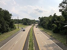
[3] Past this point, the freeway runs through marshy areas of Mantua Creek and continues into West Deptford Township.
[2][3] Continuing northeast, the freeway passes over Conrail Shared Assets Operations' Penns Grove Secondary and reaches an interchange with Route 44 and Delaware Street (CR 640).
Route 44 ends at a cul-de-sac that has a ramp from the southbound direction of Interstate 295/US 130 prior to another interchange that provides access to Red Bank Avenue (CR 644).
[1][2] The road fully enters Westville before encountering Gateway Boulevard (Route 45) at a southbound exit and northbound entrance.
[1] Upon crossing the Big Timber Creek, the route enters Brooklawn, Camden County, where the name becomes Crescent Boulevard and intersects with Broadway (CR 551 where it comes to a traffic circle.
Here, US 130 and CR 551 head concurrent to the east, passing under Conrail Shared Assets Operations' Vineland Secondary railroad line, and come to another traffic circle.
[1] At this circle, Route 47 and CR 551 head south on Broadway while US 130 continues east on Crescent Boulevard, lined with suburban shopping centers.
From this interchange, the road continues north-northeast heads across Conrail Shared Assets Operations' Grenloch Industrial Track line and crosses the Newton Creek into Haddon Township.
Following this intersection, US 130 continues through urban areas, passing through a small corner of Camden before entering Collingswood as it crosses under Conrail Shared Assets Operations' Beesleys Point Secondary railroad line.
[4] Past Haddon Avenue (CR 561), the road passes to the east of Harleigh Cemetery prior to crossing the Cooper River into Pennsauken Township.
[2] The road briefly enters Camden again right before an interchange with Federal Street/Maple Avenue (CR 537) in Pennsauken, passing under an abandoned railroad line a short distance later.
[1][2] A short distance after the Route 73 interchange, US 130 crosses North Branch of Pennsauken Creek into Cinnaminson Township, Burlington County, and continues northeast.
[1] Immediately after this interchange, the road crosses the Rancocas Creek and forms the border between Delanco to the northwest and Willingboro Township to the southeast as it passes a couple of lakes.
[1][2] Past this intersection, US 130 passes some businesses and crosses back into Burlington Township, where it runs a short distance to the southeast of NJ Transit's River Line.
[1][2] The route reaches a double trumpet interchange with the Pearl Harbor Memorial Extension of the New Jersey Turnpike (Interstate 95) in Florence Township.
[1] Following this interchange, US 130 continues through development before crossing Crafts Creek into Mansfield Township[1][2] Here, the surroundings become more wooded with a few areas of agriculture.
[1][2] After crossing the Crosswicks Creek, US 130 continues into Hamilton, Mercer County, where Route 156 splits to the west to parallel US 130 as it bypasses Yardville to the east.
US 130 narrows back to four lanes and runs around the commercial west side of Hightstown, crossing the intersection of Princeton-Hightstown Road/Stockton Street (CR 571).
[1] From this point, the route heads north through a mix of rural surroundings and inhabited neighborhoods, bypassing Downtown Cranbury to the east and crossing the intersection of Station Road (CR 615).
The road comes to a directional Y-intersection with the western terminus of Route 32, which provides access to the New Jersey Turnpike and Monroe Township.
A park and ride lot serving Coach USA buses to New York City is located west of this intersection.
Following Route 32, US 130 crosses over Conrail Shared Assets Operations' Amboy Secondary railroad line before coming to an interchange with Ridge Road (CR 522).
The section of this trail between Crosswicks and Cranbury became part of a Kings Highway connecting South Amboy and Salem.
[8] In addition, pre-1927 Route 17S was legislated to run from Penns Grove northeast to Westville in 1923; the only portion of road built ran from Pennsville Township south to Salem.
[22][23] In the late 1960s, a freeway was proposed by the Delaware Valley Regional Planning Commission to alleviate traffic on US 130 between Camden and Burlington.
[25] The proposed freeway, which was to connect the Ben Franklin Bridge to Interstate 295 near the Assicunk Creek, was to cost $53 million and mostly follow a Conrail railroad line between the two cities.