U.S. Route 23 in Michigan
The trunkline is a freeway from the Michigan–Ohio state line near Lambertville to the city of Standish, and it follows the Lake Huron shoreline from there to its northern terminus.
Future improvements to the route of US 23 include a proposed northerly extension of the freeway from Standish to one of several locations along the Lake Huron shoreline.
US 23 runs for 362.152 miles (582.827 km) through the Lower Peninsula of Michigan, serving as a freeway bypass to the west of Metro Detroit and a scenic highway through the northern portion of the state along Lake Huron.
All of US 23 in the state south of the M-32 junction in Alpena has been listed on the National Highway System,[5] a network of roads important to the country's economy, defense, and mobility.
South of Dundee, US 23 crosses the River Raisin before coming to an interchange with M-50 next to the Cabela's store west of town.
That secondary designation leaves the freeway and runs west on Washtenaw Avenue into downtown Ann Arbor and the campus of the University of Michigan.
[3][4] North of Ann Arbor, the freeway runs through woodlands and near several lakes and features a flex route system allowing traffic to use the inner shoulder during peak times.
Continuing north, the environment around US 23 transitions to rural farm fields as the freeway approaches the south side of the Flint area.
[7] Continuing northwards through suburban residential areas, the highway crosses the Flint River while running along the west side of the city.
[3][4] The highest traffic totals along US 23 in the state of Michigan were recorded by MDOT near the M-57 interchange; in 2009 an average 68,800 vehicles used that section of freeway daily.
The highway veers north, crosses the Kawkawlin River and the Pinconning Creek before coming to an interchange southwest of Standish.
In between those two junctions, the highway crosses the Au Sable River near its mouth, and the trunkline passes by the former Wurtsmith Air Force Base.
Huron Road continues north, running next to Van Etten Lake as it leaves the national forest.
The highway shifts a bit further inland north of Harrisville, continuing to parallel the railroad through the Mackinaw State Forest.
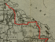
The trunkline continues to Rogers City where it bypasses town to the south and west, intersecting F-21 and M-68 in the process; Bus.
On the other side of Rogers City, US 23 runs along the lake past Hoeft State Park and along Hammond Bay before crossing into Cheboygan County.
[13] The original Shore Trail ran roughly parallel to the route of the modern-day US 23 from the Bay City area to Cheboygan.
The highway was designed to link the Great Lakes with the Gulf of Mexico, and to commemorate a half century of peace between the North and the South after the American Civil War.
The Top of Michigan Trail was designated in 1917 from the state line north to the Bay City area, before turning inland along other roadways.
As it was originally designated, US 23 crossed into Michigan from Ohio south of Temperance and ran north to Ypsilanti via Ida and Maybee.
[35][36] Around the end of the decade, US 23's routing was moved in another location to follow the lakeshore; this time the highway was rerouted between Alpena and Rogers City.
[45] North of Dundee, a more direct alignment to Azalia was added to US 23, turning the former routing back to local control in late 1947 or early 1948; at the same time, the last gravel section of the highway was paved near Hammond Bay in northwestern Presque Isle County.
[46][47] One of the first pieces of what would later become part of US 23's freeway route was completed in late 1951 or early 1952, when a two-lane bypass was built around the eastern side of Milan.
[53] The first future freeway portion of US 23 was built in 1957 from north of Ann Arbor to Whitmore Lake as a divided highway.
US 23 between Ann Arbor and Toledo was under consideration to be the location of this project;[60] the testing for such a roadway was ultimately done at Ohio State University instead.
[64] The I-75/US 23 freeway north of the Kawkawlin area to Standish opened in 1967, and M-13 was shown on maps following US 23's former route through Linwood and Pinconning after the change.
[70] The MSHD first proposed a realignment of US 223 in 1965; this change would reroute that highway to replace M-151 in southern Monroe County, and use the US 23 freeway to connect to Sylvania, Ohio.
[8] The flex route project was nationally recognized by American Association of State Highway and Transportation Officials (AASHTO) in 2018 for Operations Excellence.
[93] Since 2009, they local committee that manages the byway designation has started using the Huron Shores Heritage Route name for the corridor.
[94] At the end of 2011, the Northeast Michigan Council of Governments (NEMCOG) was working on funding a tourist promotion called "Telling Stories of the Sunrise Coast" through the US 23 Heritage Route Interpretive Program.